
![]() Purpose
Purpose
This is my final report at the end of six years as an elected member of the Waitematā Local Board. Having had the privilege of being elected for two terms to represent the central city and inner suburbs of Auckland I am not seeking re-election at this level.
At the 2015 opening of the Grey Lynn Park Greenway (l to r: Rob Thomas, Pippa Coom, Deborah Yates, Greg Moyle, Vernon Tava, Shale Chambers, Christopher Dempsey.)
I would like to acknowledge the skilled leadership of 2010-16 Board Chair Shale Chambers; his head for detail, prodigious memory and finely-tuned political antennae steered the board through many a political shallow and, as is so often the case with politicians so good at anticipating and avoiding trouble, his many achievements have not always been adequately recognised. I have also enjoyed working with 2016-2019 Board Chair Pippa Coom who is always conscientious, consultative, and has brought her characteristic fair-mindedness to the role.
I have enjoyed a great working relationship with our Ward Councillor, Mike Lee, for these two terms. He has very generously shared of his experience and wisdom over the years and I feel fortunate to have known him as a colleague and a friend.
As well as covering the period from mid-August to mid-September 2019, as per my usual monthly reports, this report also serves as a summary of the past six years (2013-2019) overall. In this time I have held the following roles on Council:
- 2013-2016: Deputy Chair of the Finance Committee; Deputy Chair of the Hearings Committee; Lead of the Parks and Open Spaces portfolio; Heritage, Urban Design and Planning portfolio holder; member of the Fukuoka Garden Working Group; and, Local Board representative on the K’ Road Business Association
- 2016-2019: Lead of the Planning and Heritage portfolio; co-holder of the Transport portfolio; member of the Auckland Domain Committee; member of the Fukuoka Garden Committee; and, Local Board representative on the Parnell Business Association
- I was certified as a resource consent commissioner in 2014 and re-certified in 2017. Over the last two terms I sat as a panel member on five hearings. The most memorable of these was as a member of a five-member panel hearing the Kennedy Point Marina consent at Waiheke Island in 2017. This decision has survived appeals to the Environment Court, High Court and Court of Appeal; leave to appeal to the Supreme Court was denied in 2021.

Speaking at the final meeting for the 2016-2019 term of the Local Board | Photo credit: Adriana Christie
Executive Summary
From 2013-2016 I led the Parks and Open Spaces Portfolio with Chair Shale Chambers. Highlights in this role include:
- Completed Stage One of the Myers Park upgrade including new playground, lighting and the installation of CCTV. Secured funding for stage two of the upgrade
- Upgraded playgrounds in Tole Reserve, Costley Reserve, and Salisbury Reserve
- Commenced the upgrade of the Western Park playground and the Grey Lynn Park playground
- Re-installed the flying fox at Western Park
- Confirmed funding for the development of multi-purpose clubrooms in Grey Lynn Park and a new home for the Richmond Rovers
- Provided additional funding to the Grey Lynn Community Centre to expand community outreach
- Secured funding for the development of the new Fukuoka Friendship garden in Western Springs and oversaw its completion
- Supported the development of a Grey Lynn pump track with a $30,000 contribution from the Community-Led Small Build Programme
- Delivered local improvement projects such as new BBQs at Cox’s Bay and additional skate elements at Victoria Park
- Secured funding and delivery of a new Victoria Park entranceway as part of Auckland Transport’s bus stop improvements on Fanshawe Street
- Creation and installation of customised park manhole covers in Albert and Myers Parks. These custom-made manhole covers were inspired by similar designs from Japan which were originally conceived as a way to involve the community in standardising Japan’s sewerage system. They have become highly local emblems that are hotly contested in design competitions. They only cost slightly more than generic covers and Myers Park was the first place in Auckland where place-specific versions were used.
In 2013-2016 I shared the Heritage, Urban Design and Planning Portfolio with Member Christopher Dempsey. From 2016-2019 I led the portfolio and shared it with Mark Davey (for the first year) and Pippa Coom.
Highlights include:
- Re-Imagining Great North Road community-led planning fund approved for Great North Road at Grey Lynn and Arch Hill
- Continued the Symonds Street Cemetery restoration with planting, new signage and trails
- Completed an inner city through-links network guide published in October 2016. This is a long-awaited project that documents, for the first time in one place, the various through-links and viewing platforms that have been granted throughout the inner city as resource consent conditions granted for the concession of bonus floors on high-rise buildings
- Completed planning, design and installation of the Heritage Foreshore Walk which illustrate and marks out Auckland’s dramatically different pre-1840 shoreline
- Completed the Karangahape Road Precinct Plan
- Completed the Domain Masterplan as a member of the Auckland Domain Committee
- Developed Earthquake Prone Buildings – guidance and approaches: a practical document for building owners, tenants and building managers with particular relevance to assuaging the concerns of owners of heritage buildings in the city who are concerned about the high costs and practical difficulties of bringing those buildings up to the new, more stringent, seismic code
- Completed the Weona-Westmere public reserve coastal walkway
- Completed the Newmarket Laneways Plan as a member of the Local Board’s working group and commenced consultation on a major Teed Street upgrade
- Completed the Parnell Plan
I have kept track of resource consent applications as they are received by Council, requesting further information, plans and Assessments of Environmental Effects for applications of interest. Significant applications are referred to the relevant residents’ associations for their input which I then relay to planners as part of the Local Board’s input. Reporting of resource consent applications, planning portfolio input, hearings and decisions in the Local Board area for this month is detailed in the Heritage, Urban Design and Planning section of this report under the headings ‘Planning’: ‘Resource Consents’
Comments
Local Government New Zealand
I attended the LGNZ conferences in 2014, 2015, 2016 and 2017 as the Local Board’s representative and as the Zone 1 representative of the Young Elected Members (YEM) network. These conferences are a great opportunity to meet and catch up with other elected members and discuss their similar and different challenges. I always learn a lot and these experiences are valuable in application to my work as an elected member on the Local Board.
The highlight of my involvement in the YEM was the launch of the LGNZ 2050 discussion paper by the Young Elected Members Network: LGNZ 2050: Futureproofing Our Communities at the 2016 conference in Dunedin. I was elected as the Zone 1 representative on the YEM in 2014 and our main project since then was to contribute a thinkpiece to the LGNZ for inclusion in their Policy and strategy work. We retained Castalia Strategic Advisors to interview sector experts and academics and write the piece guided by a steering group comprised of YEM Co-Chairs, Cr Aaron Hawkins (Dunedin City Council), Deputy Mayor ‘Ana Coffey (Porirua City Council), Cr Jinty McTavish (Dunedin City Council) and I.
I wrote the terms of reference for this project which took as its starting point the following big questions:
- What are the big challenges and issues for New Zealand over the next 30-50 years?
- The four pillars of sustainability: environmental, economic, social, cultural (and demographic)
- What are the key drivers of change?
- What are the “enduring questions” for the local government sector?
Another purpose of the project was enhancing youth participation in local government processes; building strong relationships between councils, young people and youth organisations; and, matters of Local Government New Zealand policy, and Central Government policy and legislation, on which young elected members share a view. Our over-arching focus is on intergenerational equity in all its manifestations. We see this as consistent with the core purposes of local government as codified in ss 3, 10(2)(c) and 14(h) of the Local Government Act 2002. This future focus is the perspective that will inform YEMs’ contribution to LGNZ policy and programmes, and is consistent with the overall LGNZ goal of ‘promoting and protecting local democracy’.
Sustainability is a concept that is embedded in local government legislation (‘sustainable management’ in the Resource Management Act 1991, ‘sustainable development’ in the Local Government Act 2002), policy and thinking. It is not only an environmental consideration, it has economic, social and cultural aspects. Yet, despite its theoretical centrality, it is often lacking in definition at the level of practical implementation. There is a rich body of academic literature, nationally and internationally, and numerous sustainability and low carbon strategies produced by councils throughout the country; but more needs to be done to review this body of knowledge, draw out the major themes and approaches, and assimilate them into a coherent work for discussion and policy development.
Fukuoka Garden Re-Construction
The Fukuoka Friendship Garden was demolished by CCO, Regional Facilities Auckland (RFA), in January 2014 to make way for Auckland Zoo’s Tasmanian Devil enclosure. Although RFA claimed that they had asked Fukuoka City for permission to demolish the garden, it was quickly recognised as a mistake and then-Mayor Len Brown made a formal apology. By August 2014 Council’s Sports, Recreation and Parks Committee resolved to re-instate the garden, agreeing to a $1 million + budget. Shortly afterwards, the Fukuoka Friendship Garden Steering Committee was formed, with representation from Deborah Yates and I from the Local Board, chaired by Cr Cathy Casey, two members of the IMSB and members of the Friends of Fukuoka Garden Society. The Steering Committee, including myself and Mayor Len Brown, were hosted at the home of the Japanese Consul-General on the evening of the 20 January 2015. A blessing ceremony was held at the new site of the gardens on the next day. On 31 March 2015, the Fukuoka Friendship Gardens Steering Group was re-named the Fukuoka Gardens Advisory Group. This change of name was to reflect the changing role of the group as concept plans had been produced and the governance role of the Local Board became more direct. The project presented many and varied design and budgetary hurdles but our commitment to delivering the garden never wavered. It was with a great deal of pride that I attended the official opening ceremony on 17 July 2017 and spoke for the local board in the formal speeches. The new garden is over twice the size of the original and will be a stunning asset that will only improve over time as the ageing of the garden’s components is designed into the final product.
Portfolio Report: Heritage and Planning
Portfolio Responsibilities
Heritage, Urban Design and Planning covers a mix of regulatory and non-regulatory activities including city planning and growth, heritage protection, urban design requirements, Local Board resource consent application input, and bylaw development, including advocacy to achieve local priorities relating to heritage preservation, good urban design and spatial planning. Regulatory and policy oversight of local liquor licensing, signs & billboards, and brothels.
Re-Imagining Great North Road Community-led Plan
 On May 10 2016, the Local Board resolved unanimously to approve my motion to allocate $10,000 from its Community Empowerment Fund to the Grey Lynn Residents Association (GLRA) to lead a community-led precinct vision for the area of Great North Road between Newton Road and Surrey Crescent (Resolution WTM/2016/67). The GLRA will work together with the Grey Lynn Business Association, Arch Hill Residents Association and Grey Lynn 2030 to deliver the plan.
This project has its origin in a fraught public meeting held at Trades Hall on Great North Road in late-2014. A packed hall of local residents, already incensed by the controversial Bunnings development, expressed their dismay that buildings in the area were being approved at six storeys when the District Plan (the Unitary Plan was not yet in place) envelope was set at four storeys (this is due to the operation of the Resource Management Act rather than any particular Council Policy) and a strong concern about the effect of shading on the general area that would be posed by taller buildings.
Bernard Orsman of the New Zealand Herald, reported on the 2014 meeting and wrote an in-depth piece, (‘Urban intensification: Rise of the apartment’, 6 October 2014). I was quoted as supporting intensification but also saying that resource consent applications that significantly exceed the development envelope set out in the then District Plan should be publicly notified:
Waitematā Local Board member Vernon Tava says the extra height and density being granted for Great North Rd apartment buildings is a concern to the board.
“We have a contract with the community [for four storeys],” says Mr Tava, “and if [an apartment building] is outside of that it should be notified.”
He believes it’s still not too late to bring the parties together and come up with a “whole of area approach” for Great North Rd.
I have been strongly criticised for this perspective in some quarters, particularly among self-styled ‘new urbanists’, who appear to believe that the job of elected representatives is to simply wave through any and every development proposal that comes our way. In the current climate, when the language of ‘crisis’ around housing has become so prevalent, I believe it is more important than ever that we insist on quality of design and build, and proper consultation with the community who already live in the area. How quickly the rapacious destruction of Auckland’s heritage in the ’80s and the leaky building scandal of the ’90s to the present(!) are forgotten. We must not fall victim to the sort of shoddy thinking and practice that led to these genuine and ongoing crises again.
Property developers have ample assistance in Council. I see my role as an elected member in Council primarily as representing the communities I was elected to serve and it doesn’t seem too much to ask for developments that are 50% over what was contemplated in the District Plan to be notified to the public so that they can make submissions.
It was abundantly clear at the Trades Hall meeting that in absence of good information, people will generally assume the worst. For development of any scale to fulfil its potential and contribute to the area, community consensus needs to be reached. Despite the obvious potential of this area for intensive urban residential development, Council planners have not nominated it as a strategic priority beyond supporting it being made a Special Housing Area.
In this planning vacuum, I decided that it was time for the Local Board and the community to show some leadership. The Heritage, Urban Design and Planning portfolio of the Local Board, at my direction, used hours allocated from the Built Environment Unit (BEU), a now defunct part of Council’s Design Office, to carry out an urban planning and design study on the area that is now defined as the area of the study. The study defined the area of the project and was entitled ‘Re-Imagining Great North Road’.
Local architect, Daniel Marshall – who fortuitously had a European intern who was highly skilled in urban computer-aided modeling – provided a comprehensive urban and shading study, building on the work of the BEU. The two documents will form the foundation of the community-led project and provide a strong evidential basis for its work.
The nature of urban development under the Resource Management Act is that resource consent applications are approved on a case-by-case basis without a consideration of the larger area if there is no precinct plan. Furthermore, applicants have a first-mover advantage and local residents (and the Local Board for that matter) have a largely reactive role. In any event, the Local Board can only provide non-binding input on whether an application should be notified to the public.
In practice, the process was a challenge. Many of the community representatives who had expressed such strong views made themselves scarce when it was time to do some work but two individuals have stood out throughout the process: David Batten has provided the leadership the project needed at the community level and without his efforts the project would not have proceeded past the first stage. Brandon Wilcox has also played a very important role, leading a lot of the technical work. I am very grateful to both of them for their efforts on this piece of work. Some Council officers were very helpful but others were overly bureaucratic in their approach almost derailing the project on a couple of occasions by insisting on very expensive and stringent consultation requirements that were out of all proportion to the size and nature of the project.
The final document can be viewed here.
It is my hope that this process will form a template for future community-led planning throughout the Auckland region and, perhaps, beyond.
Earthquake Prone Buildings Guidebook
Waitematā is blessed with many of Auckland’s historical buildings. Commercial buildings were commonly built of brick with decorative facades and they have a solid presence throughout the inner city, contributing enormously to its character. Although Auckland has a low likelihood of a damaging earthquake, we have a critical mass of heritage buildings that fall short of seismic performance standards and are considered earthquake prone. The process of fixing them can be confusing and costly, causing some owners to consider demolition. We are committed to the ongoing survival of the region’s rich built heritage and that includes ensuring it is structurally sound. We don’t want to see seismic strengthening work adversely affect the intrinsic value of a building nor cause the unnecessary loss of heritage through demolition.
This commitment has led us to fund and oversee the development of this guidebook as a helpful tool to guide building owners, tenants and building managers. The book is based on an exemplar project that was a co-operation between the University of Auckland Engineering Faculty and Council staff to guide building owners through the requirements and process for seismic strengthening and illustrate techniques that respect and protect heritage.
The guidebook provides a high level overview of the earthquake assessment process, an understanding of the common earthquake vulnerabilities of historical buildings, the retrofit process and an outline of the potential costs associated with this process. We have aimed to make it as accessible and easy to read as possible while retaining the necessary technical detail.
Heritage Foreshore Walk
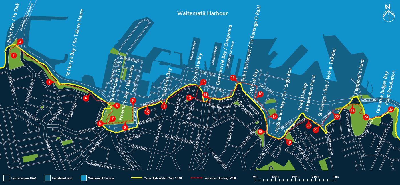
Map of the walk tracing the pre-1840 shoreline.
This is the project of which I am most proud in my two terms of Local Board work. Comprised of 25 signage sites, stretching from Point Erin to Point Resolution, that mark significant sites along the 1840 shoreline of the Waitematā area which is remarkably different from that of the present day. It is important, here, to acknowledge former Waitematā Local Board members, Tricia Reade – whose idea this originally was, then dubbed ‘The Blue Line’ – and Christopher Dempsey, who kept the idea of the project alive in the 2013 term. The original ‘Blue Line’ concept was rather more modest and would have comprised ceramic plaques mounted to buildings along the historic foreshore. The plaques were actually manufactured in early-2013 but, bizarrely, were lost during a Council office move and the project fell into abeyance. In 2015, the project was picked up by Chris Mallows, Team Leader Cultural Heritage Implementation | Heritage Unit | Plans and Places | Auckland Council. At my direction, he significantly extended the scope and ambition of the work, then designed and developed the project in the form that has been installed. I cannot praise highly enough Mr Mallows’ work. He completed it under strict time pressure, on budget, and has produced a significant contribution to Auckland’s urban landscape.
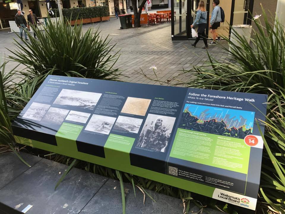
Installation 14 at the corner of Fort Street and Jean Batten Lane
I led a Heritage Foreshore Guided Walk along the original foreshore of central Auckland on Sunday 30 September 2018. This was the Local Board’s contribution to the 2018 Auckland Council Heritage Festival and follows the trail of signs installed by the Local Board earlier in the current term. 25 members of the public attended along with Local Board Chair, Pippa Coom, and Member Northey. The walk took 3 and a half hours and 10 hardy souls reached the end of the trail at Point Resolution | Taurarua.
The following introduction from the Auckland City Council research, on which the walk is based, summarises the nature of the work well:
The original shoreline in Auckland has been changed dramatically by reclamation works in the 19th to early 20th centuries, the development of rail connections, and the construction of the Harbour Bridge and motorway in 1950s and 60s. The marinas and commercial wharves, which now stretch from Westhaven through to Judge’s Bay, are very different from the foreshore sighted by the first settlers to Auckland.
Tāmaki Herenga Waka – ‘Tāmaki – the Destination of Voyagers’ is an ancient name for the Auckland Isthmus. This narrow piece of land between the Pacific Ocean and Tasman Sea was known well by the great Polynesian navigators who settled Aotearoa a thousand years ago. Waka (canoes) arriving from the Pacific Islands with new seed stocks and migrants sought the narrowest part of the isthmus at Otāhuhu, a mere 800m portage between our two great oceans. Later voyagers found Tāmaki heavily populated with some marrying into local communities while others continued south in search of new lands. With excellent gardening soils, fish stocks and natural fortifications – the volcanic cones, Tāmaki became and still is today, the centre of the largest Māori civilisation in the world. The foreshore served identical purposes for both Māori and later European settlers: closeness to the bounty of the sea, and supplies for communities, a means of travel in an era where roads were either non-existent or extremely poor, while the headlands served as defensive points.
There were a number of Māori pa sites along the original foreshore in central Auckland including Oka at Shelly Beach and Point Erin Park, Te Tō at Point Fisher, Te Ngauwera close to where the Customshouse now stands, and Te Rerenga-oraiti on what was Point Britomart.
In 1840 Lieutenant Governor William Hobson selected Auckland as the new site of the capital city, relocating it from Kororareka or Russell in the Bay of Islands. Surveyor-General, Felton Mathew, narrowed the preferred site down to Horotiu Bay (at the bottom of present day Queen Street), principally as this area was the best place for transferring both goods and settlers from ship to shore. Ngati Whatua leader, Te Kawau gifted 3000 acres of land including Auckland’s CBD to Governor Hobson enabling the establishment of the city. The British flag was unfurled on 16th September 1840 on the headland of Point Britomart, the first settlers and government officials arrived in 1841 and Auckland’s shoreline began to be transformed.
The European names of the headlands and bays along this foreshore reflect the pattern of settlement – Horotiu Bay, at the bottom of present day Queen Street, was dubbed Commercial Bay, as this was the business centre for the young capital. It offered flat, wide beach areas and mudflats. Shortland Street was the early commercial focus, but as Commercial bay was filled in and more streets formed that focus shifted to Queen Street. Further east, Official Bay on the other side of Point Britomart was where government officers first pitched their tents. Mechanic’s Bay was home to the first workmen (“mechanics”) who built the city.
The first reclamation of Auckland’s early foreshore was the formation of Fore Street (later Fort Street) from the shoreline of Commercial Bay, completed by 1850. Providing wharves was an early priority for the new settlement. The Auckland Provincial Council undertook to construct Wynyard Pier between Official and Mechanic’s Bays before the end of 1851, and commenced work on the first Queen Street Wharf in 1852. By 1859 reclamation work was in progress between Fort and Customs Streets. By 1870 the reclamation of Commercial Bay reached as far as Customs Street East and in the 1880s Quay Street was formed.
In 1871 the Auckland Harbour Board was formed which would oversee further dramatic changes to the original line of the foreshore. Once the British garrison had departed Fort Britomart, on Point Britomart headland in 1870, the new Harbour Board began in earnest to cut away the point to enable a rail connection out of Auckland. The excavated headland was used as fill for reclamations in Freeman’s, Commercial, Official and Mechanics Bays between 1872 and 1886.
Major areas of reclamation occurred in Freeman’s Bay from 1886-1917, Mechanic’s Bay from 1872-1915, and St George’s Bay from 1904-1916.
Many of Auckland’s early industries from the 19th century vanished as the reclamations spread out and the bays ceased to exist. Freeman’s and Mechanic’s Bays were the sites of sawmills, and both bays were often filled with logs. Brickfield Bay, aside from being the home for early brickyards serving the new city, was also the site for the first gas works. The building of the approaches to the Auckland Harbour Bridge in the late 1950s sealed the fate of the thriving ship building industry in St Mary’s Bay, as well as rowing regattas held by the West End Rowing Club. Of the foreshore from Pt Erin to Parnell, only Judge’s Bay retains its original contours.
The alteration of Auckland’s shoreline after 1840 until present day; from sandy beaches, rocky cliffs and mudflats – to modern wharves for passengers and container traffic illustrates the change from colonial port to modern city. In tracing the line of the original foreshore we can see the history of the development of Auckland.
Special Housing Areas
The Waitematā Local Board has generally been very supportive of the need for Auckland to intensify and Special Housing areas (SHAs), and we supported all but one: 1 Kelmarna Road, Herne Bay (R/LUC/2016/4074: application for a five-storey apartment building; R/REG/2016/4078: application for groundwater diversion and discharge, R/REG/2016/4075: application for stormwater diversion and discharge). The Herne Bay pub site was the first (and only) SHA proposal to go before the Governing Body for support that we as the Local Board formally and unapologetically opposed with considered detailed reasoning. The prior, fully canvassed, similar proposal that the Environment Court had decided was inappropriate for the area, as well as current outstanding opposing submissions still before the Unitary Plan Panel, were the primary reasons.
I followed plans regarding this site closely since it was considered for inclusion in the Special Housing Area (SHA) scheme. The venerable local pub, The Gables, on the corner of Jervois and Kelmarna Roads in Herne Bay was declared an SHA in the penultimate Tranche 9 of the Special Housing SHA application approval process was announced on February 11 2016. This means that the application is not subject to the usual notification, consultation or appeal processes to which resource consents are usually.
The Local Board’s detailed reasons for opposition were that:
- It failed to meet the lack of controversy criteria for an SHA.
- The site has a significant litigation history. A very similar application was declined by Auckland City Council in 2006. That decision was appealed in 2007 based on a revised proposal for a 300m2hospitality unit and a 142m2 retail unit fronting Jervois unit; 925m2 of offices in nine units, five with frontage to Kelmarna and four facing to the western boundary; four apartments at 1st and 2nd floor on Jervois, four townhouses with access from Kelmarna and/or Jervois; 56 basement carparks; on Jervois Rd: three-level on corner, to 12.5m height, retail shops, tavern and four residential units above; on Kelmarna Ave: a three-level office building, ten terraced units (four residential and six commercial) with two levels to maximum height of 8m (matching surrounding Residential zone). The proposal was rejected by the Environment Court due to concerns with the combined effect of bulk and location of proposed buildings. In the words of Judge McElrea (KRJR Properties v Auckland City Council: ENV-2007-AKL-000663 (Decision No. A 088/2008)), ‘the dominance of the development produced by the high level of site coverage, the lack of buffer yards on the northern and eastern boundaries, the loss of direct sunlight to residential properties in Kelmarna Avenue, and the lack of meaningful landscaping on most boundaries,’ [119] and ‘[i]n another context this development might be admirable. In this location it seems out of place with considerable detrimental effects.’ [59] These very same concerns are triggered by the, almost identical, current SHA proposal.
- This SHA application is substantially similar to the rejected 2007 proposal, although with almost 30% greater height, which would only be permissible under proposed zoning changes under the PAUP.
- Zoning has not yet been settled under the Unitary Plan and there are seventeen submissions against increased height and density in the area and at the specific site.
- There is a proven record of considerable community opposition to further development of the site that would be thwarted by the SHA process. This opposition is reflected in Unitary Plan submissions and the history of litigation.
- We are uncertain that the wastewater/stormwater infrastructure is adequate to support an intensive development of this scale.
Unfortunately, our considered and thoroughly-researched local views were disregarded and the Governing Body, on a very close vote, narrowly supported this proposal proceeding to the Minister who approved it.
Online Maps
In my role as the Planning Portfolio lead for the Local Board, I created a Google Map of the heritage sites of the Local Board area. This was initially to have a quick reference against which to check consent applications but it made sense to share it publicly and it appears to have been useful to a reasonable number of people with 4,171 unique views at the time of writing.
This prompted me to map the area’s scheduled (‘Notable’) trees which has been viewed by just under 3,000 people.
By far the most popular map (41,704 unique views at the time of writing) is one I created that includes the bonus floor spaces, toilets and drinking fountains of the Local Board area. In the process of mapping the bonus floor space features, I noticed that neither Council nor Auckland Transport had up-to-date maps of the central city’s public toilets or drinking fountains. I added these to the bonus floor feature map.
Resource Consent Applications
I have kept track of resource consent applications as they were received by Council by reading the weekly spreadsheet that is sent out to all elected members. These enquiries have been reported in my monthly reports to the Local Board, published in every business meeting agenda and on this site. Very few elected members check the weekly spreadsheet but it is essential to do so if one is to be sure to know what is happening in their local board area.
When I was first elected we would rely on an agreed list of ‘triggers’ which would prompt planners to bring applications to the responsible members of the board, i.e. the two who hold the planning portfolio, but elected members simply cannot rely on Council staff to inform them of all significant consents and we would be blind-sided by controversial consent decisions on a troublingly regular basis.
The most egregious of these was in early-2015 when we were not informed about an application by Ports of Auckland Limited to extend Bledisloe Wharf 98 metres into the harbour. This particular application caused widespread public outrage and when media asked questions of Council about whether elected members had been informed, they were told that a spreadsheet is emailed to members every week and they should have seen it there. So, future elected members, you have been warned.
After this incident I took to perusing the spreadsheet weekly and following up on consents myself. I identified significant or otherwise interesting applications, paying particular attention to coastal, tree, apartment building, public space and heritage area consents. Once identified I would request further information, plans and Assessments of Environmental Effects for the relevant projects. Significant applications have generally been referred by me to the relevant residents’ associations for their input which I then relay to planners as part of the Local Board’s input. I would make decisions as to whether the Local Board would request limited or full notification of the consent (these requests are not binding and the final decision on notification is generally made by a Duty Commissioner) and whether we would have input at any hearing that may be held in the rare instances of notification. On some significant applications we will include substantive comments along with our views on notification.
I’ve filed these monthly reports and published them online primarily as a database of the huge number of consents that I have dealt with in this Local Board area which are far too numerous to recall otherwise but I’m reliably informed that the reports have a small but dedicated readership and are actively discussed on a site called skyscrapercity.com, a forum dedicated to high-rise buildings (and ‘skyscrapers’, ‘supertalls’ and ‘megatalls’) and the people who love them.
This month’s applications:
- 300 Parnell Road, Parnell. LUC60342140. Additions and alterations to the exterior of the existing building and comprehensive development signage package.
- 23 Windsor Street, Parnell. LUC60341325. Demolition of three residential units and reconstruction of the same three residential units on a residentially zoned site.
- 99 Gladstone Road, Parnell. LUC60341394. Construction of a six-unit apartment building and associated site works.
- 6 York Street, Newmarket. LUC60341206. External building alterations in the Metropolitan Centre zone and the Special Character Areas overlay, including signage.
- 62 Remuera Road, Newmarket. LUC60341293. Application to construct a 33-unit visitor accommodation development on a business – mixed use zoned site
- 31 Argyle Street, Herne Bay. LUC60341108. Dwelling additions, Single House zone, Character Overlay , PC26.
- 61 Wakefield Street, Auckland Central. LUC60343659, New proposed hotel development.
- 539-541 Parnell Road, Parnell. LUC60343926, WAT60343925. The construction of two new buildings containing ground floor offices and residential apartments and associated site works, including tree removal and the diversion of groundwater.
- 110-116 Carlton Gore Road, Newmarket. LUC60344094. This application by Mansons TCLM involves the demolition of the existing buildings and the construction of a new seven-level commercial office and retail building, with associated basement parking over two levels. Resource consent is also sought for the proposed basement construction and the associated earthworks and infrastructure installation.
- 43 Argyle Street, Herne Bay. LUC60344288, SUB60344289. Demolish existing dwelling and boatshed, and construct new dwelling, garage, boatshed in substitution as well as associated site works within the drip line of coastal trees.
Significant Resource Consent Matters
Update on Downtown Programme of Works and America’s Cup-related Resource Consent Applications
- Seawall strengthening – Ferry Building Section – Applicant AT
New palisade seawall landward of existing seawall around the Ferry Building. The works are proposed for seismic strengthening purposes to improve resilience in the event of an earthquake, in particular by protecting Quay Street and the services within it. This is the fourth (and last) section of seawall in the Downtown Programme. The other three sections have been granted resource consent and construction has commenced. Full public notification of the resource consent closed on 21 August. At this stage it is possible that it may not go to a hearing as only one submission has been received to date, and it is in support.
- Downtown Public Space – Applicant AT
The proposal includes the construction, establishment, operation and maintenance of a new public open space in the Ferry Basin between Princes Wharf and Pier2/Ferry Building. Full public notification occurred in June/July 2019. A hearing was held on 9-11 September. Sixteen submissions received: six opposed, three in support, seven neutral. The key issues raised were mana whenua consultation, noise and vibration, heritage, and transport.
- Other consent applications for the Downtown Programme of works
There are a few other smaller consent applications being processed including the Downtown Ferry Terminal design amendments (the Downtown Ferry Terminal has been consented, this is for a variation to the consent). The lodged variation includes more robust attachments to Queens Wharf and some changes to the edge between the wharf and the ferry terminal gangway structures.
Other consent applications being processed in the Downtown/Viaduct area include:
- Wynyard Crossing Bridge – Applicant Panuku Development Auckland
Replacement bridge for Wynyard Crossing linking Te Wero Island and Karanga Plaza. The submission period closed on 28 August. At the time of writing, 43 submissions had been received with key issues pertaining to the lack of light rail/heritage tram and provision for cyclists. A hearing is likely to be held in October/early November 2019.
The following AC36 and Downtown Programme-related resource consents have been granted:
| Resource Consent Application | Status |
| America’s Cup 36 – Insfrastructure and events | Granted – construction started |
| Sealink Ferry Re-location | Granted – construction started |
| Mooring Dolphin | Granted – currently under appeal |
| Daldy Street CSO Outfall Extension and discharge relocation | Granted – construction started |
| Seawall – 3 sections – Queens Wharf to Marsden Wharf, Princess Wharf, Ferry Basin | Granted – construction started |
| Downtown Ferry Piers 3 and 4 relocation | Granted – construction started |
| Quay Street Enhancement | Granted – construction started |
| Wynyard Crossing – existing bridge temporary consent | Granted – construction not required |
| Relocation of WWI Memorial Beacon | Granted – not yet started |

A mightily impressive and detailed report Vernon; correctly emphasising the depth of work you with colleagues have undertaken with the community in your six years on the board. It has been an honour to serve on this board with you these last two terms.