
![]() Purpose
Purpose
This report covers my Waitematā Local Board Activities in mid-June to mid-July 2019 as Lead of the Planning and Heritage portfolio; co-holder of the Transport portfolio; Local Board representative on the Parnell Business Association; and, member of the Auckland Domain Committee.
Executive Summary
- Plan Change 26 to the Auckland Unitary Plan: a review of the conflict between zones and overlays in AUP was consulted in June. A summary of the plan change is in the Heritage & Planning portfolio report below
- The Parnell Plan was finished and publicly launched on 26 June
- Completed, with Member Northey, Local Board input on the Kainga Ora Bill currently before Parliament
- I keep track of resource consent applications as they are received by Council, requesting further information, plans and Assessments of Environmental Effects for applications of interest. Significant applications are referred to the relevant residents’ associations for their input which I then relay to planners as part of the Local Board’s input. Reporting of resource consent applications, planning portfolio input, hearings and decisions in the Local Board area for this month is detailed in the Heritage, Urban Design and Planning section of this report under the headings ‘Planning’: ‘Resource Consents’
Portfolio Report: Transport
Local Board Chair, Pippa Coom, writes a very comprehensive report on transport in her monthly Chair’s Report. I refer the reader there for detail on the work of the Transport Portfolio.
Saint Patrick’s Square Bollards Re-Installation
The project manager informs us that the contractor quote has now been accepted for this work but that the timeframe for delivery of the removable bollards from overseas is 8-10 weeks so the revised date for installation is mid-September at the latest. We had hoped that this relatively simple installation could be a quick win, so this is rather frustrating given that my motion was passed at our meeting of 16 October 2018.
Portfolio Report: Heritage and Planning
Portfolio Responsibilities
Heritage, Urban Design and Planning covers a mix of regulatory and non-regulatory activities including city planning and growth, heritage protection, urban design requirements, Local Board resource consent application input, and bylaw development, including advocacy to achieve local priorities relating to heritage preservation, good urban design and spatial planning. Regulatory and policy oversight of local liquor licensing, signs & billboards, and brothels.
Proposed Plan Change 26 to the Auckland Unitary Plan: resolving conflict between Zones and Overlays in Unitary Plan
Plan Change 26 seeks changes to the Auckland Unitary Plan to make it clear that certain planning provisions of the underlying Special Character Areas Overlay will prevail over the corresponding provisions of the underlying residential zones. The proposed plan change also refines some of the standards within the Special Character Areas Overlay, including height in relation to boundary, yards, paved areas and fences.
One of the most important things to understand about this plan change is that it is not introducing new rules or standards; it is clearing up an inadvertent legal confusion and effectively bringing the old Res 1 controls back into play, which were the heritage protections of the old District Plan for the last 20 years or so.
The issues that the plan change deals with arose when the Auckland Unitary Plan became operative in part in November 2016. The final wording of the rules for Special Character Overlay Areas and the underlying Single House Zones were, in places, inconsistent and created uncertainly about which should take precedence. Council obtained external legal advice to determine the correct interpretation of the rules and adopted the approach that the Special Character Areas Overlay rules took precedence over the underlying zone rules between December 2016 and December 2017.
The legal position was clarified in three Environment Court cases: Auckland Council v Budden [2017] NZEnvC 209, Auckland Council v Budden (No 2) [2018] NZEnvC 3 and Auckland Council v Budden (No 3) [2018] NZEnvC 30. The Environment Court did not agree with Council’s existing interpretation of the rules and declared that both sets of rules – the Special Character Areas Overlay and the underlying zoning rules – should apply when considering resource consent applications.
Following this, hundreds were advised to re-apply for their consents in September 2018.
The challenge of dealing with these issues is summarised at p. 26 of the Coombes & Williams Overlay Analysis Report, December 2018:
‘There is no simple amendment that can address all of these issues collectively. It would not be appropriate to introduce a general rule that makes the overlay provisions always prevail over zone and Auckland-wide provisions. This would create issues when the overlay provisions are more permissive than their equivalents elsewhere in the plan, but the overall intent of the overlay is to be restrictive. In such cases the overlay is not meant to enable particular activities where there are other reasons for a zone to restrict that activity. Such an approach would create anomalous situations such as the Volcanic Viewshafts Overlay allowing building heights up to a sloping viewshaft height when the building height in the surrounding zone is lower.’
The wording of the proposed change is (full document here):
Chapter D18
- Amend the introductory text preceding Activity Table D18.4.1 Special Character Areas Overlay – Residential to state:
- That Activity Table D18.4.1 does not apply to land use activities;
- That the activity status of activities in Activity Table D18.4.1 takes precedence over the activity status of that activity in the underlying zone;
- That the activity status in the relevant zone applies to land use activities and to development activities that are not specified in Table D18.4.1; and
- That all other relevant overlay, precinct and Auckland-wide rules apply unless otherwise specified.
- Amend Activity Table D18.4.1 Special Character Areas Overlay – Residential to:
- Insert a new activity rule to provide for the construction of new fences and walls, and alterations to fences and walls that comply with Standard D18.6.1.7(1) as a permitted activity; and
- Insert a new activity rule to state that the construction of new fences and walls, or alterations to fences and walls, that do not comply with Standard D18.6.1.7(1) is a restricted discretionary activity.
- Amend D18.6.1 Standards for buildings in the Special Character Areas Overlay –Residential to:
- Clarify that the development standards listed within D18.6.1 apply to all activities undertaken in the Special Character Areas Overlay – Residential, whether they are listed in Activity Table D18.4.1 or in the relevant zone; and
- State that the following development standards in D18.6.1 prevail over the equivalent development standards in the underlying zone (except where otherwise specified):
- building height
- height in relation to boundary
- yards
- building coverage
- maximum impervious area
- landscaped area
- fences and walls
- Include a purpose statement for the following development standards:
- building height
- height in relation to boundary
- yards
- building coverage
- landscaped area
- maximum impervious area
- fences and walls
- Amend Standard D18.6.1.2 Height in relation to boundary to specify that:
- The control (3m + 45 degree recession plane) only applies to sites with a frontage length of less than 15m;
- The underlying zone height in relation to boundary standard applies:
- To sites that have a frontage length of 15m or greater; or
- Rear sites.
- Standard D18.6.1.2 only applies to side and rear boundaries (not front boundaries)
- Standard D18.6.1.2 does not apply to site boundaries with an existing common wall between two buildings on adjacent sites or where a common wall is proposed;
- Standard D18.6.1.2 applies from the farthest boundary of legal rights of way, entrance strips, access sites or pedestrian access ways; and
- That gable ends, dormers or roofs may project beyond the recession plane in certain circumstances.
- Delete the rear yard requirement from D18.6.1.3; and state that the underlying zone yard standards apply for all other yards.
- Amend the reference to ‘maximum paved area’ in D18.6.1.6 to ‘maximum impervious area’; along with associated amendments to the maximum levels in Table D18.6.1.6.1.
- Amend the standard that relates to fences and walls in D18.6.1.7 to the effect that fences constructed between the front facades of houses and the street are limited to 1.2m in height, but can be up to 2m in height elsewhere on a site.
- Amend D18.8 to require an assessment of resource consents against the matters of discretion and assessment criteria set out in D18.8 as well as the matters of discretion and assessment criteria in the underlying zone (for infringements to equivalent standards only). For clarity, PPC 26 does not propose any amendments to the following standards in Chapter D18:
- Objectives
- Policies
- Table D18.4.2 Activity table – Special Character Areas Overlay – Business
- Notification
- 6.2 Standards for buildings in the Special Character Areas Overlay – Business
- Assessment – controlled activities
- Special Information Requirements
Chapter E38: Subdivision – Urban
Amend Standard E38.8.2.6 to state that the minimum net site area standards in Table E38.8.2.6.1 prevail over the zone-specific standards in Table E38.8.2.3.1.
It may appear that the intensity of the Special Character Areas is being increased when compared to the underlying residential zoning of Single House Zone (SHZ) but it is important to be sure that we are comparing like with like. An historic analysis shows that the Special Character Areas (i.e. Grey Lynn, Ponsonby) were relatively intensively developed compared to today’s standards and, for consistency, the standards for new builds and alterations in the area reflect this. The Plan Change 26 Evaluation Report contains the following table summarising the phases of development in Auckland’s isthmus suburbs with the sizes of the lots and frontages:
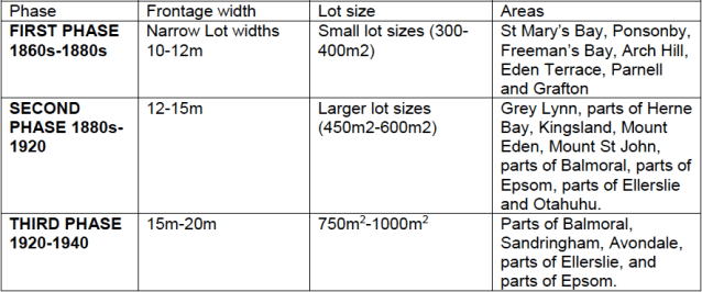
These rules reflect the existing, historic building pattern – houses were traditionally built much closer and higher relative to the boundary and were extended at the back over time. So, for example, it is worth noting that the height in relation to boundary in the Special Character Area of 3m + 45 degree recession plane only applies to properties that have a frontage of less than 15m.
This plan change is not creating new rules, nor is it allowing additional development, it is reinstating the same (‘Res 1’) rules that have existed in the affected area for the last 20 years. Prior to the Unitary Plan, the Auckland District Plan had a special ‘Isthmus A’ zoning area for Grey Lynn and Ponsonby. This recognised that lots in these historic suburbs tend to be much smaller and narrower than modern subdivisions, by allowing owners to:
A) build to a height to boundary starting at 3m on boundary (same as current overlay rules but the old District Plan only required 1 m side yard)
B) smaller lots to build on a greater proportion of the land. The District Plan used a different formula from the current overlay rules but the effect was similar – you could build on 35% of a 500 sqm lot, 40 % on a 400 sqm lot, rising to 50% for a 200sqm lot.
Auckland Council, via the Unitary Plan process, opted to simplify the large number of zones it inherited from the six prior District Plans. It did this by creating residential zones based on the primary housing types in each area, e.g. single house zone, allowing 1 house per lot, or terraced housing and apartment zone, etc. The single house zone set a minimum lot size of 600 sqm – a size rarely found in our historic neighbourhoods. Note also that the SHZ permits existing housing to be demolished as of right!
Proposed Plan Change 26 clarifies the Unitary Plan by stating that the overlay rules will overwrite the zone rules while tidying up a few minor issues like changing maximum paved area to impervious surface area. It does not add additional development rights, it just continues the rules that have existed for over 20 years.
If development were restricted to SHZ rules, we’d lose more of our heritage buildings. Owners no longer able to build behind their existing house may instead choose to build over the existing building, or seek permission to demolish entirely.
Public input closed on the 12th of July, 2019 after being extended by two weeks to allow for increased public engagement.
Parnell Plan Completed and Launched
The Parnell Plan was finished and publicly launched on 26 June at Jubilee Hall.
Scheduled tree cut down without permit at 73 Argyle Street, Herne Bay
We are still waiting to hear what, if any, enforcement action will be taken regarding this matter. Council is investigating and no public updates will be available until they have concluded that investigation.
Liquor Licensing Applications
There were no new, off-licence liquor licence applications or renewals this month in the Central alcohol licencing area that raised any concern for the Local Board.
Resource Consents
The portfolio request information on resource consent applications of interest as a matter of course. The Local Board can have input into the decision on public notification of a resource consent application and can also comment on the substantive matters of the application. The input of the Local Board is not binding on the commissioner or hearings panel making the decision but we are able to appear at notified hearings to speak on behalf of the Local Board. This is not treated as a submission for the purposes of the Resource Management Act but it is given weight by a hearings panel or commissioner according to the merit of the arguments made.
Significant Resource Consent Matters
‘The Lookout’ Observation Deck on Viaduct Harbour Avenue, Viaduct Harbour
CST60339966. Construction of an 30-metre long observation deck near Waitematā Plaza in the Coastal Marine area. Viaduct Harbour Holdings Limited seeks consent to construct an observation deck (coined ‘The Lookout’) within the Viaduct Harbour. It will extend from the Viaduct Harbour Promenade near the Waitematā Plaza, 30m out in to the Viaduct Harbour. The new publicly accessible observation deck is part of VHHL current work to update the Viaduct Harbour Promenade area including upgrades to furniture and replacement of paving. Overall consent is required as a restricted discretionary activity and includes numerous consent matters including construction, use and occupation of an observation deck within the Coastal Marine Area; impact and vibratory piling; construction time longer than 40 days being 3-4 months; exceedance of noise levels arising from piling activities. I shared this information and the application materials with the City Centre Residents Group. The Local Board have request that this application be publicly notified on the basis that it is a use and occupation of the Coastal Marine Area; it is an extension into the harbour which our constituents have expressed very strong views about (regardless of whether it is in the main shipping channel or the enclosed area of the Viaduct Harbour); the effects on the nearby residential buildings of impact and vibratory drilling and construction running for 3-4 months will be much more than minor and will cause significant disruption throughout the area.
Mixed-use apartment development, 339-361 Great North Road, Grey Lynn (Arch Hill Caltex site)
339 Great North Road, Grey Lynn. LUC60340118. Mixed-use apartment development, comprising two levels of basement carparking, refuse and storage, ground floor retail units, communal facilities and apartments, and six levels of upper floor apartment units at 339 to 361 Great North Road, Grey Lynn. The development will be contained in two separate buildings on separate titles and include a total of 84 apartment units. I am yet to receive plans and the application documentation; we’ll be following this application very closely.
Wynyard Crossing Bridge
220 Quay Street, Auckland Central. CST60340406, LUC60340405. The demolition of the existing Wynyard Crossing bridge, the construction of a new bridge and the installation of a temporary crossing for the duration of the construction activities. The current pedestrian bridge linking Viaduct Harbour with Wynyard Quarter, was built for the Rugby World Cup in 2011 and is reaching the end of its life. The current bridge has a Resource Consent in place until August 2020. The proposed new Wynyard Crossing bridge is intended to provide for the same users as the current bridge, whilst also allowing greater pedestrian capacity and improved safety. The current alignment will be utilised for the replacement bridge, as it is known to best suit pedestrian movements. If future works do eventually propose an east-west tram line connection along the Waterfront, the Te Wero alignment, connecting further south of Te Wero island with Jellicoe Street could be considered.
Provision was made within the Long Term Plan (LTP) for a replacement bridge. The LTP underwent the required public consultation. Following the adoption of the LTP in June 2018, a decision was made in August 2018 that Panuku was the logical entity to deliver the replacement bridge. Following this, consideration was given as to whether the Wynyard Edge Alliance (WEA) were in a position to deliver the replacement bridge. It was determined that WEA should focus on the delivery of critical America’s Cup (AC36) infrastructure; so, although the consent will go ahead, the bridge won’t be constructed until after the AC36.
The Local Board’s input seeks a bridge design that is wide enough to separate between cyclists and pedestrians as best practice on a very busy route with lots of potential for conflict between modes. This echoes CCRG and Bike Auckland’s positions.
Application Withdrawn: Removal of a mature Pōhutukawa tree located within 150 metres of mean high water springs, 89 Saint Marys Road, Ponsonby
TRE60335782. Everyone is aware of the removals of precious trees when it happens and we, understandably, hear a lot about these but protection of the trees often happens in a quieter, less public fashion. This is one such example. The applicant wanted to remove a large, mature Pōhutukawa tree to provide more daylight for an existing dwelling and future developments. The application was transferred to a planner to process as the Council arborist was unable to support it. The Local Board requested public notification with a recommendation that it be declined; following this and an adverse Council opinion the application was withdrawn.
Other Consents
- 48 Garnet Road, Westmere. LUC60339336, SUB60339335. Land use consent to construct 2 new dwellings and 2 lot subdivision. The subject site is zoned Residential – Mixed Housing Suburban under the AUP(OP). The site is not subject to any overlays or controls that are relevant to this application but there is an overland flow path which intersects with the front of the site and this will be assessed by Council’s Development Engineer. Proposed lot 1 contains the front dwelling with an area of 470m2. Proposed lot 2 contains the rear dwelling with an area of 400m2. The proposal requires resource consent under Table E12.4.1 for earthworks (747m2 required). And under E38.8.2.1(A14) for the subdivision component. Given the high level of compliance with the plan, after seeking plans and the AEE document from the planner, the Local Board had no input on this application.
- 383 Great North Road, Grey Lynn. LUC60339457. Change the use of the existing commercial building including internal and external alterations to the existing commercial building for a community centre & short-term stay shelter facility for a woman’s refuge. The Local Board did not have input into this application.
- 55 Kelmarna Avenue, Herne Bay. LUC60339393, SUB60339394. Development of three dwellings and associated three-lot freehold subdivision. The proposal involves the demolition of the existing dwelling (a permitted activity in this zone). The applicant then seeks to establish three new double storey dwellings on the site. Main issues appear to be relationship to neighbouring sites to the north and south and there are potentially adversely affected persons in that regard given non-compliance with yards and height in relation to boundary standards. Site also has flooding to the rear which needs some further investigation before the Council engineer is happy with it. From a streetscape character point of view, it is a relatively attractive addition. The application is currently on hold under s92 whilst further information is supplied by the agent. The Local Board has recommended limited notification to the neighbouring sites.
- 64 Curran Street, Herne Bay. LUC60339675, SUB60339676. This involves the demolition of the 2 existing dwellings on the site, construction of two new dwellings and subdivision around these with a boundary adjustment along the accessway to 62 Curran Street. The applicant has provided written approval from 62 and 66 Curran Street. The Local Board did not have input into this application.
- 71 Albany Road, Herne Bay. LUC60339810. Additions and Alterations to an existing one-storey dwelling. This site is under a Historic Heritage overlay and within the Residential Isthmus A area. Albany Road has had a very high protection level for some years now although this isn’t always enough to protect historic sites. The proposal is for excavations to extend a basement, ground floor extension to the rear of the dwelling, upper-floor extension creating a two-storey dwelling and changing the roof form, establishing a swimming pool to the rear. The application is currently on hold for further information. Local Board input is that it is unlikely to be supported in its current form.
- 55 Islington Street, Ponsonby. TRE60340642. Removal of one Claret Ash tree. This tree is in close proximity to power lines and must be removed. The Local Board did not comment on this application.
