
![]() Purpose
Purpose
This report covers my Waitematā Local Board Activities in mid-July to mid-August 2018 as Lead of the Planning and Heritage portfolio; co-holder of the Transport portfolio; Local Board representative on the Parnell Business Association; and member of the Auckland Domain Committee.
Executive Summary
- I attended the official opening of the Teed Street renovation and sculpture
- I attended a Parnell Plan meeting on 30 July
- I have attended Parnell Business Association committee meetings for July and August as well as the PBA’s presentation to the local board on 9 August
- I met with Warren Wilson of the Newton Business and Residents Association on 16 August to discuss liquor licensing issues in the area
- Auckland Domain has picked up a bronze award in the World Urban Parks 2018 International Large Urban Parks Award. The Domain is the only NZ urban park amongst the winners
- I keep track of resource consent applications as they are received by Council, requesting further information, plans and Assessments of Environmental Effects for applications of interest. Significant applications are referred to the relevant residents’ associations for their input which I then relay to planners as part of the Local Board’s input. Reporting of resource consent applications, planning portfolio input, hearings and decisions in the Local Board area for this month is detailed in the Heritage, Urban Design and Planning section of this report under the headings ‘Planning’: ‘Resource Consents’
Portfolio Report: Heritage and Planning
Portfolio Responsibilities
Heritage, Urban Design and Planning covers a mix of regulatory and non-regulatory activities including city planning and growth, heritage protection, urban design requirements, Local Board resource consent application input, and bylaw development, including advocacy to achieve local priorities relating to heritage preservation, good urban design and spatial planning. Regulatory and policy oversight of local liquor licensing, signs & billboards, and brothels.
Parnell Plan
I attended a meeting of the Working Group on the evening of 30 July. We covered the Parnell Plan 2018 – Final Update (feedback overview), report on Tuk Tuk Activation for the Parnell Plan (Parnell Business Association), collated feedback comments (a large document with all the written feedback); Working Group terms of reference.
We will meet again on the 27th of August and 10th September.
Resource Consents
The portfolio request information on resource consent applications of interest as a matter of course. The Local Board can have input into the decision on public notification of a resource consent application but not into the substantive matters of the application. The input of the Local Board is not binding on the commissioner making the decision. Nonetheless, on some significant applications we will include substantive comments along with our views on notification.
- 8 Seccombes Road, Epsom. LUC60321547. The construction of six terrace houses. Application by Top Chain Investment Holdings Ltd to establish 6 x four-storey town houses on the now-vacant site. Significant earthworks are proposed to lower the ground level to enable the four levels. General compliance is achieved with relevant bulk and location standards in the zone. The Local Board did not have input into this consent application.
- 62 Curran Street, Herne Bay. LUC60321644. Full upgrade and alterations to existing house proposed addition to existing outhouse addition of separate new studio. Application to undertake extensive works to the dwelling to remove out of character additions and alterations and to restore to a more traditional type of dwelling suitable with the period. Extension to a guesthouse is proposed, and this was never lawfully established as such so consent is also needed to convert to a dwelling. A new studio accessory building is also proposed. Notable infringements to yard, height and height in relation to boundary exist. The Local Board did not have input into this consent application.
- 4-10 Alma Street, Newmarket. SUB60322230. Application by Mansons to undertake a three lot freehold subdivision around an existing land use consent that established a 6 storey office block in Newmarket. Relatively straight forward application that will involve no physical works and is simply to amalgamate the currently 5 messy titles into two title that have half share in the third title. The Local Board did not have input into this application.
- 8 Putiki Street, Grey Lynn. LUC60322234. The construction of a 6-storey building to accommodate three levels of office and a two-level penthouse apartment. The Local Board did not have input into this application.
- 1B Albany Road, Herne Bay. LUC60322853. Construction of new office building. Consent includes demolition of an existing building estimated to have been constructed in the 1970s, understood to have been variously used as a Plunket rooms and, most recently, a medical laboratory. The building has no outstanding architectural or heritage qualities. The building will be single storey with a pitched roof and a mezzanine floor. The Local Board did not have input into this consent.
- 95-99 St Marys Road, Ponsonby. TRE60322446. The translocation of three juvenile pōhutukawa trees located within St Marys Road Park, to provide space for the construction of the St Marys Bay and Masefield Beach Water Quality Improvement Project. The Local Board did not have input into this consent.
- 2/53 Anglesea Street, Freemans Bay. LUC60323461. Auckland Council Healthy Waters is proposing to separate a portion of the existing combined (storm water/wastewater) network.
- Wharf: 11-99 Brigham Street, Auckland Central. CST60323353. Upgrades to the eastern Queens Wharf cruise ship berth to provide for the mooring of cruise ships up to 362m (Oasis Class Vessels) involving construction of two new cruise ship mooring dolphins located at distances of 49m and 82m (to the centres of the dolphins) north of the northern end of Queens Wharf, a gangway connection to Queens Wharf including hydraulic retractable gangway and security gates, strengthening of the southern end of Queens Wharf, seven new additional wharf bollards on the east. The Local Board recommended public notification of this consent
-
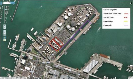
36-54 Brigham Street, Wynyard Quarter
36-54 Brigham Street, Auckland Central. LUC60323413, DIS60323415. Application by Panuku & Stolthaven to remove all of the existing buildings and structures located at the Stolthaven South Terminal site and the Sail NZ yard at Brigham Street, Auckland Central (36-54 Brigham Street and the southern portion of 56 Brigham Street). The site is currently occupied by Stolthaven and a Panuku Tenant (Explore Group/Sail NZ). The site is located on the eastern side of the northern point of Wynyard precinct. The site currently provides for the storage of chemicals within 12 tanks and associated above ground pipelines. The proposal involves the decommissioning and demolition and removal of the storage tanks and associated structures and the pipe work which traverses across Brigham Street. There are no new structures or buildings proposed as part of this consent. Reasons for consent include: removal of buildings on land requires consent as a controlled activity within Wynyard Precinct (I214.4.2 (A47). Subject to rule E11.4 (A9) the proposal will involve earthworks of greater than 2500m2 within the sediment control protection area this is a restricted discretionary activity. Subject to Rules E12.4.1A(6) and (A10) the proposal involves earthworks in excess of 2,500m3 involving limited earthworks to remove above ground infrastructure, earthworks to remove private stormwater infrastructure and the potential for up to 100m3 of earthworks in relation to spot remediation. As such consent is required as a restricted discretionary. In this case the works will take place involving contaminated soil, subject to rule C1.9 (2) non-compliance with the are considered as a restricted discretionary activity. The proposal will involve works within the rootzone of the street trees on Brigham Street and Hamer Street, this is a restricted discretionary activity. The DSI identifies that the soil investigations exceed the permitted activity levels for contaminates. As such the proposal will involve discharges of contaminants into air, or into water, or onto or into land from disturbing soil on land containing elevated levels of contaminants. This activity does not meet the permitted activity standards in E30.6.1.2 but meets the controlled activity standards in E30.6.2.1 and is therefore a controlled activity. The Local Board did not have formal input into this consent.
- 13-15 College Hill, Ponsonby. LUC60323553. College Hill Police Station. The site is located on College Hill although pedestrian and Vehicular access is from Gudgeon Street. The site is located within the Mixed Use zone and all sites adjacent are within the Mixed Use zone. The site currently contains two levels of basement parking and six levels of offices. The site is subject to the volcanic viewshaft control and the centre fringe office control but is not subject to any other limitations. This application involves the change of use of the existing office building to emergency services. This only includes the offices for the New Zealand Police. The only external changes required are anti-climbing barriers to the inside of the carpark decks, a gate to the loading deck and some internal changes to the glazing for privacy in the offices. The reasons for consent include: Rule H13.8.1 (A31) ‘emergency services’ are a restricted discretionary activity within the Mixed Use zone; alterations to building facades that are less than 25m2 are permitted. The total area of changes to the exterior of the building façade is approximately 66m2, this is a restricted discretionary activity (Rule H13.4.1(A47). There are currently 196 underground carparks, with 201 proposed (with some additional stacked internally). The Local Board did not have formal input into this consent.
Significant Resource Consent Matters
5-storey ‘Car Handling Facility’ on Bledisloe Wharf
More detail in a separate post here. LUC60323081. An application by Ports of Auckland Limited (POAL) at 1-19 Quay Street (on the Bledisloe Terminal) for earthworks required to facilitate the construction of a new car handling facility building. The consent matters are limited to earthworks and NES only – new buildings within the Port Precinct which comply with the relevant standards are a permitted activity. The works will involve 3000m2 and 2000m3 of earthworks, which primarily relate to the construction of the footings and foundations required to support the proposed building. Consent matters include the undertaking a proposed volume of earthworks exceeding 2500m2 and undertaking a proposed volume of earthworks exceeding 2500m2 within the Sediment Control Protection Area (i.e. within 100m of the coastal area). The works also trigger consent matters under Section 9(1) of the Resource Management (National Environmental Standard for Assessing and Managing Contaminants in Soil to Protect Human Health) Regulations 2011 (NES) as a controlled activity, as the works exceed the permitted earthworks volume. No discharge consents are being applied for, as the applicant (Ports of Auckland) is the holder of a permit to discharge contaminants from an industrial or trade activity (Discharge Consent 25179).
It should be borne in mind that this approach by POAL is in direct response to widespread public pressure, opposing expanding the POAL land area by reclamation of the harbour for cargo storage, including cars, (especially for cars). I strongly oppose further reclamation so I find it difficult to object to intensification of the use of Port land. However, given the strong public interest in the port and the environmental sensitivity of the area, I think that public notification is appropriate.
The Local Board recommended public notification of this consent on the basis that ‘special circumstances’ exist as per s 95A(9) RMA 1991. The special circumstances are the very high level of public interest in development of the port land and the consistently expressed expectation of our constituents that they will have the opportunity to have input on such works. It is understood that this consent is for earthworks and NES matters only, not the building (as it is a permitted activity if complying with the relevant standards); nonetheless, there are likely adverse effects from the earthworks which exceed the permitted earthworks volume particularly given the proximity of these works to the water (within the Sediment Control Protection Area), and it is the Local Board’s view that the external expertise on these matters that can only be accessed by way of a public notification process is important for the matter to be adequately considered.
Auckland Waterfront Apartments – Wynyard Quarter
BUN60321932. 121-127 & 129-135 Beaumont Street and 184 & 200 Pakenham Street West, Auckland. Demolition of existing buildings and construction of six buildings on 9793 square metres of land bounded by Gaunt Street, Daldy Street, Pakenham Street West and Beaumont Street. Exceeds a number of standards, including site intensity and height controls. The applicant proposes that the permitted baseline can be taken from the existing Goodman Integrated Development Plan (IDP), an unimplemented resource consent for development site intensity and building heights. The Goodman IDP was approved in October 2015, I reported on it in my Local Board Report of that month:
Decision: Integrated Development Plan (IDP) QA2 for 121-127 and 129-135 Beaumont Street; 184 and 200 Pakenham Street; and 61- 69 Daldy Street
GRANTED with conditions: R/LUC/2015/2098. Application made by Goodman (Paihia) Limited. The IDP is to enable the future integrated development of 9,793m2 of land in Quarter Area 2 (QA2) of Wynyard Quarter to provide a framework of permissible built form, massing, open space, traffic and parking effects and activities across the block of land. In addition, the proposal seeks to modify development controls relating to the maximum height, site intensity, office GFA, maximum parking rates, reduction in exclusive marine and fishing activity, removal of the required north-south lane, and various other traffic related matters. The application proceeded on a non-notified basis. The land use consents were for district land use consent (DLUC) to provide car parking for more than 100 vehicles relating to an activity; DLUC for the provision of vehicle accesses with Defined Road Boundaries; DLUC to breach the requirement for on-site loading spaces to be provided, with none being provided for the proposed buildings on the southern side of the block; DLUC for an IDP where there is a concurrent development control infringement to exceed maximum IDP site intensity and maximum parking; DLUC to permit the transfer of 3310m2 of GFA from the Sailor’s Corner site at 2 Westhaven Drive, being a Character Building located in QA3. The transfer of GFA to another quarter area in Wynyard Quarter is not provided for as an activity in the district plan; DLUC for greater than 100m2 of GFA for office, marine and fishing retail, retail, food and beverage, entertainment/gathering or education activities; DLUC to infringe the IDP maximum height as follows:
- Building 1: proposed maximum height 27m where 25m plus 2m roof is permitted
- Building 2: proposed maximum height 27m where 25m plus 2m roof / 31m is permitted
- Building 3: proposed maximum height 35m where 31m is permitted
- Building 4: proposed maximum height 35m where 31m is permitted
- Building 6: proposed maximum height 27m where 25m plus 2m roof is permitted
- Building 7: proposed maximum height 39m where 25m plus 2m roof is permitted
- Building 8: proposed maximum height 31m where 25m plus 2m roof / 31m is permitted
- Building 9: proposed maximum height 39m where 31m is permitted
- Building 10: proposed maximum height 31m where 25m plus 2m roof / 31m is permitted
DLUC to modify street frontage alignment and height control to permit “gaps” between the buildings from the first floor level up; DLUC to infringe the maximum IDP site intensity (GFA) where 4.5:1 and 4:1 in part is permitted and across the site, 4.8:1 has been granted; DLUC to increase the total office GFA for QA2 to 74,032m2 involving a maximum GFA of 19,375m2 for the proposed IDP and 54,648m2 for approved IDP2; DLUC to exceed the maximum parking ratios for office activity where 1/150m2 of GFA was permitted and 1/100m2 has been granted, and for residential activity where 1/80m2 of GFA was permitted and 1/67m2 of GFA has been granted; DLUC to modify the ‘Access to Sites with Multiple Frontage’ development control that applies on Daldy Street where vehicle access will be provided through Special Character Frontage into the East/West Lane, and vehicle exit will be provided onto Beaumont Street; DLUC to modify the vehicular access over footpaths development control to provide vehicle access from Daldy Street, being subject to Special Character Frontage controls; DLUC to modify the Lanes and View Shafts development control as no north-south lane as previously required will be provided. DLUC to modify the requirement for marine and fishing activity at ground level as detailed in Quarter Plan E. No viewshafts have been removed (or reduced in width) under the IDP. The only potential lanes that are being removed are the north south lanes through the two small blocks owned by Goodman and Panuku Development Auckland between Gaunt and Madden Streets.
The development will be taken up in two stages. Stage One involves construction of buildings on the northern portion of the site, buildings 1-3, and formation of the publicly-accessible lane between Beaumont and Daldy Streets. This will include 180 of the residential apartments and approximately 1,830m2 of ground floor retail. It is anticipated that the full basement area will be built as part of the Stage One works, incorporating up to 505 car parking spaces, with the anticipated final allocation upon completion of the development being 251 for Stage One and 254 for Stage Two. Stage Two of the development will involve the building of the remaining three buildings on the southern portion of the site, buildings 4-6, and the publicly-accessible plaza space. This will include 164 residential apartments, 90 serviced apartments and approximately 1,782m2 of retail.
- Building 1: 62 apartments over 10 levels, 878m2 of ground floor retail. Maximum height of 35.6m at the southern end stepping down to 18.7m at the northern end.
- Building 2: 110 apartments over 12 levels, 670m2 of ground floor retails. 43m at the southern end, 29.2m at the northwest end.
- Building 3: 88 apartments over 3 levels, 281m2 ground floor retail. The building is 12.7m high.
- Building 4: 51 apartments over 12 levels, 503m2 ground floor retail. 43m at southern end, 32m at the northern end.
- Building 5: 63 apartments over 13 levels, 485m2 ground floor retail. Maximum height of 46.6m.
- Building 6: 50 apartments, 90 services apartments over 13 levels, 793m2 of ground floor retail. 46.6m at eastern end, 29.3m at the western end.
There are three publicly accessible lanes provided through the development and a large publicly accessible plaza space.
Given the sheer scale of the development and the numerous infringements, the Local Board has requested public notification of the application.
