
![]() Purpose
Purpose
This report covers my Waitematā Local Board Activities during May 2017 as Lead of the Heritage, Urban Design and Planning portfolio; co-holder of the Transport portfolio; Local Board representative on the Parnell Business Association; and, member of the Auckland Domain Committee.
Executive Summary
- Heritage Foreshore Trail signs have been installed across the Local Board area.
- Resource consent has been lodged for the Mansons TCLM Special Housing Area apartment development at 1 Kelmarna Avenue, Herne Bay. There is significant history behind this application which is detailed in the report below.
- Resource consent application has also been lodged for a Special Housing Area apartment development at the King’s Arms Tavern site, 57-59 France Street South, Eden Terrace. More on this below.
- AT is stopping the road at 6-8 York Street, Parnell. Currently used as a car park.
- AT will be trimming trees along Great North Road in the inner western suburbs to make way for double decker buses being added along this route.
- I keep track of resource consent applications as they are received by Council, requesting further information, plans and Assessments of Environmental Effects for applications of interest. Significant applications are referred to the relevant residents’ associations for their input which I then relay to planners as part of the Local Board’s input. Reporting of resource consent applications, planning portfolio input, hearings and decisions in the Local Board area for this month is detailed in the Heritage, Urban Design and Planning section of this report under the headings ‘Planning’: ‘Resource Consents’.
Portfolio Report: Heritage, Urban Design and Planning
Portfolio Responsibilities
Heritage, Urban Design and Planning covers a mix of regulatory and non-regulatory activities including city planning and growth, heritage protection, urban design requirements, Local Board resource consent application input, and bylaw development, including advocacy to achieve local priorities relating to heritage preservation, good urban design and spatial planning. Regulatory and policy oversight of local liquor licensing, signs & billboards, and brothels.
Heritage Foreshore Panels Installed
This is the project of which I am most proud in my last four years of Local Board work. Comprised of 25 signage sites, stretching from Point Erin to Point Resolution, that mark significant sites along the 1840 shoreline of the Waitematā area which is remarkably different from that of the present day. It is important, here, to acknowledge former Waitematā Local Board members, Tricia Reade – whose idea this originally was, then dubbed ‘The Blue Line’ – and Christopher Dempsey, who kept the project alive in the 2013 term. The original ‘Blue Line’ concept was rather more modest and would have comprised plaques mounted to buildings along the historic foreshore. The plaques were actually manufactured in early-2013 but, bizarrely, were lost during a Council office move and the project fell into abeyance. In 2015, the project was picked up by Chris Mallows, Team Leader Cultural Heritage Implementation | Heritage Unit | Plans and Places | Auckland Council. At my direction, he significantly extended the scope and ambition of the work, then designed and developed the project in the form that has been installed. I cannot praise highly enough Mr Mallows’ work. He completed it under strict time pressure, on budget, and has produced a significant contribution to Auckland’s urban landscape. The official opening will be held on 20th June.


The huge amount of reclamation and very different shape of the original shoreline can be seen in this detail
Resource Consents
The portfolio request information on resource consent applications of interest as a matter of course. The Local Board can have input into the decision on public notification of a resource consent application but not into the substantive matters of the application. The input of the Local Board is not binding on the commissioner making the decision. Nonetheless, on some significant applications we will include substantive comments along with our views on notification.
- R/LUC/2017/1336, 47 Norfolk Street, Ponsonby. Overlay – Special Character Residential Isthmus ‘A’, Single House Zone. Return street elevation to original condition, small extension to the rear. We did not have input into the notification decision.
- R/LUC/2017/1342, 120 Williamson Avenue, Grey Lynn. New driveway and double garage under existing home. The proposed double garage will be constructed completely under the existing house. There will be a new awning built over the garage door to delineate the existing villa from the garage. This awning will be built in the same materials and style as the existing roof, with corrugated iron and exposed rafters. The 5.4m wide driveway will be constructed of exposed aggregate concrete with a maximum gradient of 1:5 sloping down to the garage. This proposal has a permit for the proposed vehicle crossing: VXI Permit Number: B/VXI/2016/2349. The proposal will retain an existing stone wall. We did not have input into the notification decision.
- R/LUC/2017/1344, 125 Queen Street, Auckland Central. The proposal involves new ASB Bank branding signage to the exterior of the Category B scheduled heritage façade of the former BNZ bank building at 125 Queen Street. Resource consent is required as the signage is affixed to a heritage feature. The proposal is supported by the Council’s built heritage specialist and written approval has been received from Heritage New Zealand. Overall it is to be assessed as a restricted discretionary activity. We did not have input into the notification decision.
- R/LUC/2017/1375, 8 Hereford Street, Freemans Bay. The proposal includes a two-level addition to the east of the main existing tower building , containing office and retail space, as well as 40 short-term, non-accessory (public) parking spaces. The roof of the addition will have a tennis court and swimming pool for private use by the residents in the main tower apartments. Access to the parking spaces will be from Mahon Way. Consent is required for additions and alterations in the City Centre Zone ((A36) of Table H.8.4), an infringement of the maximum height standard, of approximately 1.5m (Standard H8.6.2), an infringement of the basic floor area ratio standard (Standard H8.6.10), and for short-stay non-accessory car parking ((A14) of Table E27.4.1). Overall, it is a non-complying activity. We did not have input into the notification decision.
- R/LUC/2017/1396, R/REG/2017/1397, 35-39 Wakefield Street, Auckland Central. The proposal is to construct an accommodation building to service AUT undergraduate students. The development comprises two accommodation buildings; a 15 level northern tower fronting Mayoral Drive; and a 16-level southern tower located above a 6-level podium. A central pedestrian lane traverses the site connecting Wellesley and Airedale Streets. The proposal requires regional and district land use consents under the Auckland Unitary Plan – Operative in Part. Buildings are designed to conform with prevailing development controls. Some works are within the dripline of protected trees on Mayoral Drive thus requiring consent. Regional consents relate to earthworks and diversion of groundwater. Overall it is to be assessed as a restricted discretionary activity. We did not have input into the notification decision.
- R/VCC/2016/5138/1, 5 Judge Street, Parnell. Changes fit within the scope of minor variation.
- R/LUC/2017/1496, 70 John Street, Ponsonby. Alterations and additions to a dwelling in a Special Character Area, including partial demolition. Replacement and widening the existing driveway; a new front path and stairs to the main entrance; new landscaping and lawn within the front yard; a new front veranda; internal modifications resulting in new window positions; replacement of joinery where required; demolition of a rear lean to and construction of new kitchen, laundry, dining and living spaces; construction of a new rear patio and stairs to the existing lawn; new roofing and skylights. No significant infringements, so the Local Board did not have input into the notification decision.
- R/LUC/2017/1505, 34A Arthur Street, Freemans Bay. Alterations and additions to the front of an existing dwelling including: the existing deck and carport structure will be reconstructed to form an extended living space for the ground floor area adjoining the southern site boundary. As part of this, the existing uncovered deck above will be reconstructed with new balustrade; an open pergola structure will be constructed adjoining the reconstructed deck, adjoining the northern site boundary, with a storage shed below; a new skylight will be installed in the roof of the existing dwelling to allow natural light to permeate the building; the rear yard will be landscaped, with an open timber pergola, brick seating, concrete pavers and a poured concrete slab. A new fireplace flue. We did not have input into the notification decision.
- R/LUC/2017/1507, 16 Harcourt Street, Grey Lynn. Renovation to existing villa and proposed extension to rear of house. Single car garage to be removed from the street elevation and a pool to be added to the rear of the section. Conversion of a 4 bedroom, 1 bathrooms home to a 4 bedroom, 1 study, 2 bathroom home with modern living spaces.
- R/LUC/2017/1601, 633A Great North Road, Grey Lynn. Demolition of the existing dwelling to construct a new residential dwelling in its place. Proposed development is fully compliant with relevant development controls.
- R/LUC/2017/1602, 217-223 Hobson Street, Auckland Central. Demolition and construction of 2 residential buildings – 186 apartments and ground floor retail. The proposal is to remove existing buildings on the site and replace with an apartment development comprising two towers, one having frontage to Hobson Street and the other having frontage to Nelson Street, separated by a 20m landscaped outlook court. The Nelson Street tower will contain retail at ground level and 95 apartments over 12 levels and the Hobson Street tower ground floor retail and 91 apartments over 11 levels. The two towers contain a mix of two and three bedroom apartments. Vehicle access will be solely from Nelson Street with two levels of parking providing a total of 237 parking spaces. Consent matters relate to demolition of existing buildings, construction of new buildings, infringement of gross floor area requirements (MTFAR) and access within a motorway interchange control area. Whilst the proposed development may require regional consents in relation to earthworks, discharge of contaminants and or diversion of groundwater, no applications accompany this land use consent application and clarification is being sought from the applicant in this regard. The proposal requires non-complying activity resource consent.
- R/LUC/2017/1623, 60 Sarsfield Street, Herne Bay. Demolition/Removal of existing dwelling and construction of new dwelling on site. Key elements of the project include: demolition/removal of the existing 1960s dwelling and the majority of existing vegetation on the site. The hedge along the rear is to be retained in part; construction of a new dwelling which is predominantly single storey except where it features a lower level garage at the front, and an upper level bedroom near the centre of the dwelling; outdoor areas comprise a terrace area, which includes a pool and timber deck, and a large area in lawn at the rear of the site. At the site frontage it is proposed to reinstate the existing 1.8m high fence as the location of the vehicle and pedestrian gates will change as part of this proposal. A new driveway will be constructed to provide access to the garage, and will utilise the existing vehicle crossing; approximately 296m³ of cut and fill across a total area of approximately 481m² are required to generally level parts of the site, construct the dwelling foundations, and the driveway. There is a reticulated stormwater line available for connection within the road reserve, the applicant has prepared drainage services plans for a public extension to the site boundary.
- R/LUC/2017/1631, 34 Shortland Street, Auckland Central. External alterations and additions to an existing building to establish a cafe, and alterations to the existing through site link. Land use consent is sought for alterations and additions to an existing building and modifications to the building’s existing through site link. The proposed works include the construction of a new “glass box” addition for a café/meeting space along the building’s Shortland Street frontage, alterations to the existing site entrances from Shortland Street and Fort Street, replacement of the existing verandah along Shortland Street with a larger verandah, and enclosing and upgrading the building’s existing through site connection from Shortland Street to Fort Street. The works do not change the height or main façade of the building, and the through site link will continue to be retained and accessible by the public. However the proposed addition at ground floor for the café/meeting space will result in a gross floor area (GFA) increase of 86m2. The proposal requires non-complying activity resource consent.
- R/LUC/2017/1637, 103-107 Saint Stephens Avenue, Parnell. Erect a new residential dwelling on site.
- R/LUC/2017/1713, 15-17 Sturdee Street, Auckland Central. The proposal is to replace an existing 12m (wide) by 5m (high) static billboard mounted to the wall of the building at 15-17 Sturdee Street, Auckland Central, with a new 5m (wide) by 9m (high) digital billboard display. The proposal requires resource consent because billboards on a street facing building façade in the Business – City Centre zone are a discretionary activity pursuant to Rule E23.4.1(A28).
- R/LUC/2017/1716, 7 Union Street, Auckland Central. The proposal is to replace an existing 12 metre (wide) x 3 metre (high) static skin billboard attached to the roof of the existing building at 7 Union Street with a 15.36 metre (wide) x 5.12 metre (high) LED digital display billboard. The proposal also involves the removal of two other existing 12 metre (wide) x 3 metre (high) static skin billboards attached to the street facing facades of the buildings located at 7 Union Street and 9 Union Street.
- R/LUC/2017/1722, 44 Glanville Terrace, Parnell. Construction of new dwelling. Demolition of the existing dwelling (not subject to the demolition control); construction of a new dwelling with basement garage and swimming pool. Earthworks with an area of 257m2; construction of a new fence/wall (1.8-2.5m) within the front yard; removal of a street tree that does not trigger a reason for consent given the small size of the tree. We did not request notification for this application.
- R/VCC/2012/3145/32, 29 Pollen Street, Grey Lynn. Variation of condition 3 of the previously approved resource consent to increase the height of the building and the finished floor to floor height of the apartment building. The proposed changes will infringe the maximum height by 1.143m and 1.243m for the roof top structure. The floor to floor height of the building will also be 2.6m which is 1m below the minimum 3.2m. We did not request notification for this application.
Resource consent matters of significance this month
59 France Street South, Eden Terrace. King’s Arms Tavern. Special Housing Area
R/LUC/2017/1641. Resource consent for a qualifying development to demolish the existing buildings on site and construct a new 6-level mixed use building containing 104 apartments, 235m2 of commercial space (in two tenancies), and basement parking. As tends to be the case with SHAs, this site has a storied history. The King’s Arms has been one of the city fringe’s few remaining mid-size venues, important for promoters to ‘test out’ international acts before putting them on bigger stages. The site was declared a Special Housing Area in April 2016, following an application by Urban Collective. It sold for $7 million later that year, the purchasers promising that it would remain open until 2018. A petition launched when word of the sale got out, calling for “the centre of the Auckland music scene” to be saved. The petition garnered about 6,000 signatures, although it was unclear exactly who has supposed to stop the sale or how a property transaction between two private parties could be prevented. For some useful context, Russell Brown, Auckland cultural writer and proprietor of the Public Address blog, makes an interesting point to place this development within the historic sweep of the area (‘About The King’s Arms (updated)’, publicaddress.net, 10 April 2016):
It’s worth noting that this is also an area where many more people used to live, before the motorway junction built in the 1960s forcibly displaced as many as 30,000 residents and radically changed the character of the area’s commercial strip, Karangahape Road. So in that sense, Newton is going back to what it was.
1 Kelmarna Avenue, Herne Bay. Special Housing Area
Current Consent – Earthworks
R/LUC/2017/1531. For earthworks to excavate the proposed basement level of the development. This application is to be considered under the Housing Accords and Special Housing Areas Act 2013 as distinct from the Resource Management Act 1991. Generally the various ‘consents’ that make up an application are considered together. However, on larger scale developments and/or subdivisions it is common practice to obtain consents for the earthworks prior to the building itself. There are many reasons a developer will do this but often there are seasonal restrictions on earthworks and financial implications if earthworks are delayed until the building or activity is consented. The Local Board have a long and well-documented record of asking for local participation in the consent process for this site and so will be asking for notification to the adjacent properties to the fullest extent that it is possible under the HASHAA legislation.
The applicant made some small design changes to the façade treatment as a result of Urban Design Panel recommendations. This hasn’t changed the overall building envelope however. There has been considerable delay since then as the applicant worked through infrastructure matters around stormwater disposal. I understand from the processing planner that a solution has been reached with the agreement of Watercare and Healthy Waters, which will enable stormwater from the site to be connected to the separated stormwater infrastructure upgrades that will occur in the near future.
Background
The Waitematā Local Board has generally been very supportive of the need for Auckland to intensify but the Herne Bay ‘Gables’ pub site was the first (and only) SHA proposal to go before the Governing Body for recommendation to the Minister that we formally and unapologetically opposed with considered detailed reasoning.
The Local Board’s reasons for opposition were that:
- It failed to meet the lack of controversy criteria for an SHA.
- The site has a significant litigation history. A very similar application was declined by Auckland City Council in 2006. That decision was appealed in 2007 based on a revised proposal for a 300m2 hospitality unit and a 142m2 retail unit fronting Jervois unit; 925m2 of offices in nine units, five with frontage to Kelmarna and four facing to the western boundary; four apartments at 1st and 2nd floor on Jervois, four townhouses with access from Kelmarna and/or Jervois; 56 basement carparks; on Jervois Rd: three-level on corner, to 12.5m height, retail shops, tavern and four residential units above; on Kelmarna Ave: a three-level office building, ten terraced units (four residential and six commercial) with two levels to maximum height of 8m (matching surrounding Residential zone). The proposal was rejected by the Environment Court due to concerns with the combined effect of bulk and location of proposed buildings. In the words of Judge McElrea (KRJR Properties v ACC ENV-2007-AKL-000663 (Decision No. A 088/2008)): ‘the dominance of the development produced by the high level of site coverage, the lack of buffer yards on the northern and eastern boundaries, the loss of direct sunlight to residential properties in Kelmarna Avenue, and the lack of meaningful landscaping on most boundaries,’ [119] and ‘[i]n another context this development might be admirable. In this location it seems out of place with considerable detrimental effects.’ [59] These very same concerns are triggered by the, almost identical, current SHA proposal.
- This SHA application is substantially similar to the rejected 2007 proposal, although with almost 30% greater height, which would only be permissible under proposed zoning changes under the PAUP.
- Zoning has not yet been settled under the Unitary Plan and there are seventeen submissions against increased height and density in the area and at the specific site yet to be heard by the Independent Hearings Panel.
- There is a proven record of considerable community opposition to further development of the site that would be thwarted by the SHA process. This opposition is reflected in Unitary Plan submissions and the history of litigation.
The Governing Body, on a very close vote, narrowly supported this proposal proceeding to the Minister. Unfortunately, our considered and thoroughly-researched local views were disregarded.
Portfolio Report: Transport
Road Stopping at 6-8 York Street, Parnell
A Notice of Requirement has been lodged to stop the road at 6-8 York Street, Parnell. The sliver of road land shown in red below is not required for road purposes and the owner of 6-8 York Street requested to acquire the land.
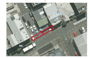
6 York Street was subdivided in 1987 into Lots 1 and 2, DP 114582. Lot 2 was constituted as road by Auckland City Council in May 1987 by Special Order B690654.1 under the Local Government Act 1974. The applicant wishes to acquire Lot 2.
8 York Street comprises Lot 1, on CT 2029/79. This subject parcel of land to be acquired has an area of 25m² being a strip of 2.6m width. The land was formally acquired in 1990 by Auckland City Council with a Compensation Certificate registered on the Title in March 1991 (C248710.1), however was not subsequently legally vested as road. The applicant wishes to acquire this land. Road/land can only be disposed of to an adjoining owner. This adjoining owner has approached AT as they are currently using it as part of their carpark. By stopping this area of road the road alignment will now be a straight line and not the ‘dogs leg’ it currently is. AT have told us they will never turn this area into a live road.
For clarity, Marston Street does not go through to York Street. Therefore there is technically no public access from Marston to York as 6 York Street is private land – currently used for parking. There is no ‘legal’ pedestrian access from Marston to York as 6 York (the current parking lot) is privately owned.
City centre tree works for Great North Road Double Decker Clearance
AT Metro are currently designing the works needed to implement double decker bus routes in the city centre. This memo relates to the last leg of the Great North Road (GNR) from New Lynn Transport Centre to City centre.
The City Loop starts from the intersection of Karangahape Road and Pitt Street towards Vincent Street, Mayoral Drive, Albert Street, Victoria Street West, Hobson Street and back onto Pitt Street. Buses will layover on Cook Street in between service.
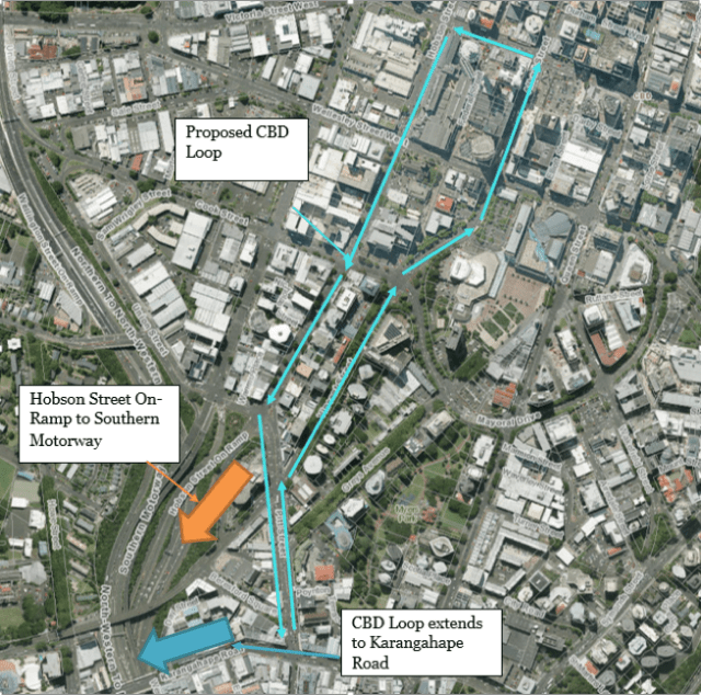
The GNR route is scheduled for double decker service from June 2017.
Double Decker Bus Clearance Requirements
Double decker buses have a height of 4.25m and width of 2.5m. To operate, they need the following clearances:
- a vertical clearance of 4.75m and horizontal clearance of 1m from the front of the kerb at bus stops to accommodate the greater ‘swing’ of the new DDR bus types as the move in and out of stops; and
- a vertical clearance of 4.75m and horizontal clearance of 0.5m from the front of the kerb on other locations along the road corridor.
To clear the route, AT needs to carry out:
- Tree pruning on 65 street trees and one private tree
- Power, telecommunication other service pole relocations
- Street signage – removals and relocations
Most of the pruning and the street pole/signs relocations are permitted activities under the Auckland Unitary Plan, Operative in Part (AUP(OP)).
There are 29 Notable street trees which require some level of pruning. AT has assessed that 3 Notable (scheduled) Tulip street trees require pruning in excess of the permitted rules. These Tulip Trees are located on the north-western side of Mayoral Drive (just behind the Aotea Centre) where city bound buses services currently stop and layover.
Resource consent to prune all 66 trees will be sought from AC to sanction works to both the 3x Tulip trees and for any other cases where tree pruning may exceed the AUP(OP) permitted levels.
The AC Heritage arborist has provided his written consent for the proposed tree works.
Tree pruning activities for which resource consent is not required includes work to:
- an American Sweet Gum Tree located outside of Auckland City Mission (140 Hobson Street) and the tree owners have provided their written consent; and
- an Oak Tree located within along the western property boundary of St Matthew-in-the-city Church (132 Hobson Street).
AT lodged the resource consent for the tree works at the end of May.
Teed Street Upgrade
Auckland Council is upgrading Teed Street as part of the Waitematā Local Board’s Newmarket Laneways Plan, to greatly improve footpath widths, enabling easy pedestrian movement along and across the street.
The existing ‘patchwork’ concrete carriageway – a remnant of the light industrial past is retained and complemented with new quality paving materials, bespoke street furniture and upgraded street lighting. Native evergreen street trees planted within bio-retention tree pits achieve significant improvements to stormwater quality.
Construction
Work on site commences on Monday 22nd May 2017 with construction continuing for approximately 8 months. The project is split into three stages, detailed below:
Stage One
Construction will be starting on the northern side of the road, working in an easterly direction from the Crowhurst Street to Osborne Street intersection, including:
- drainage and services upgrades,
- vector future proofing,
- tree pit construction,
- raised speed table at Teed & Osborne Street intersection.
Stage Two
When the speed table is complete, works will recommence on the northern side of the footpath, working in an easterly direction from Crowhurst Street to Osborne Street, including:
- excavating footpaths,
- laying kerbs,
- pouring concrete,
- completing landscaping.
Stage Three
When Teed Street’s northern footpath is complete, construction will begin on Teed Street’s southern footpath, working in a westerly direction from Osborne to Crowhurst Street, including:
- excavating footpaths,
- laying kerbs,
- pouring concrete,
- preparation works for new art installation
- completing landscaping.

