
![]() Purpose
Purpose
This report covers my Waitematā Local Board Activities during November 2014 as Deputy Chair of the Finance Committee, Deputy Chair of the Hearings Committee, Lead of the Parks and Open Spaces portfolio, Co-holder of the Heritage, Urban Design and Planning portfolio and Local Board representative on the K Road Business Association.
Executive Summary
- This month marks one year that I have been a member of the Waitematā Local Board.
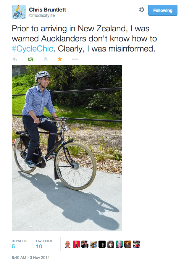
- This has been a great month for cycling advocacy. Chris and Melissa Bruntlett of Modacity Consultancy in Vancouver presented an Auckland Conversations talk on 4 November and also participated in a Generation Zero-organised ride, ‘Blending with the Bruntletts’, on 2 November.
- I attended the two-day foundation course for RMA independent commissioners, funded from the Local Board professional development budget.
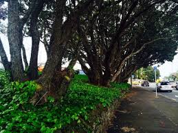
- The Local Board submitted against the AT Notice of Requirement to remove a row of eighty year-old pohutukawa trees from the side of Great North Road opposite MOTAT.
- Work is progressing on the re-establishment of the Fukuoka Friendship Garden at Western Springs. A video-conference between the Steering Committee (including myself and Member Yates) and the Fukuoka City Greenery Department team was held on 2 December.
- Lighting in Western Park became a controversial topic in the last two weeks of the month with reporting in national media on a proposal to remove lighting from the park on a public safety basis. This will be consulted on as part of the Western Park Development Plan in early-2015.
Comments
‘Making Good Decisions’ RMA Independent Commissioner Foundation Course
On 4-5 November, I attended the Independent Commissioner Resource Management Act foundation course, ‘Making Good Decisions’. This was funded from the Local Board professional development budget for $1986.00. As the course was held in Auckland there were no additional costs.
As a portfolio holder in the Heritage, Urban Design and Planning portfolio, I am called upon with great regularity to provide local board feedback on resource consent applications in the Waitematā Local Board area. I found the course to be hugely instructive and consider it to be essential for a planning portfolio holder. The resource consents process is highly technical and requires specialised knowledge of the Resource Management Act 1991, District Plan, Proposed Auckland Unitary Plan and Council processes.
To provide informed input into resource consent and planning processes it is necessary to understand not only the planning instruments but also the manner in which hearings are conducted. This course has been invaluable in providing training and insight into these processes and has equipped me with the ability to perform at a high level in my portfolio role.
My first, pre-course, assessment worth 20% of the total mark was graded as passed with ‘Merit’.
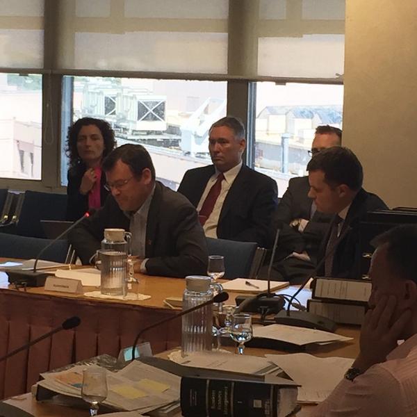
St Luke’s Intersection Notice of Requirement Hearing on 5-6 November
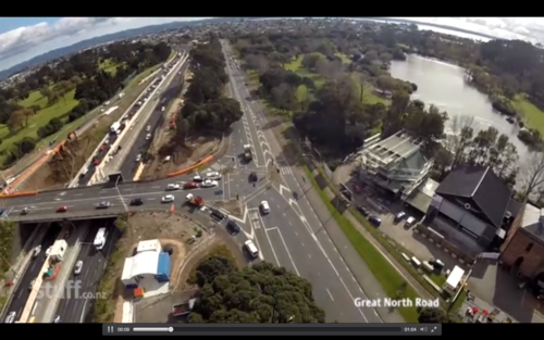
Photo credit: public address blog.
It was fortuitous – having just completed two days of RMA hearing training the day before – to attend a full day of hearings regarding a matter on which the Local Board was the main submitter in opposition.
AT propose the removal of six mature Pohutukawa trees from the side of Great North Road on either side of the St Lukes intersection. This is to allow for two lanes of traffic to turn on to the North Western Motorway on the eastern side of the St Lukes bridge intersection. This is the Local Board’s boundary with the Albert-Eden Local Board and on the western side of the intersection the boundary runs along Great North Road as far as Motions Road. The reserve in which the trees stand, 820 Great North Road, is Parks land and the Waitematā Local Board is the landowner.
 AT are the notifying authority under the Resource Management Act 1991 (RMA) and they are acquiring the land for the works by way of a Notice of Requirement (NoR). The Local Board decided to bring a NoR objection. We retained counsel from Nick Whittington of Meredith Connell, funded by Council with expert witnesses paid for by the Local Board.
A Notice of Requirement is what a designation is called before it is confirmed. It gives notice of an intention to use land in the future for a particular development. When confirmed, the notice of requirement is called a designation and is included in a district (or unitary) plan, often as a listing or schedule, with any associated conditions that provide for the work and set out any particular way in which effects are to be avoided, remedied or mitigated. Only a requiring authority can require a designation to be provided for in a district or unitary plan. The requiring authority in this case is Auckland Transport (AT). A board of inquiry was convened to conduct hearings and they will make a recommendation to the requiring authority but ultimately, the decision is AT’s alone and they can theoretically disregard the recommendation of the board of inquiry.
Because of an error communicated among public submitters, the wrong file number was written on no less than 54 of the public submissions. There were two applications related to these works: one, a resource consent hearing, for the additional stormwater works required with a significant increase in impermeable area when the trees are removed; the other, the notice of requirement for the roading designation. One of the submitters accidentally put the number for the resource consent on their submission and communicated this to many other submitters who likewise accidentally submitted on the wrong application. Oddly, though, four submitters who didn’t put any number on their submission was accepted as having validly submitted. The consequences of these simple clerical errors have threatened to overshadow the legitimacy of the NoR hearing and have been widely reported. On the second day, when opposing submissions were heard, only three members of the public were heard by the Board of Inquiry. One of these submitters was told that she would be heard but that her submissions would not be mentioned in the final report and could not legally be considered by the Board.
 The Local Board’s submission centred on the consideration that AT had given to an Option 6. In their analyses of the St Lukes Road upgrade, the New Zealand Transport Agency (NZTA) and AT identified the provision of one or two westbound lanes turning left from Great North Road to St Lukes Road. This was to address queuing issues during the evening commuter peak period. AT and NZTA concluded that two lanes would be required which would necessitate the removal of the six Pohutukawas. This option was included in the July 2013 application to Auckland Council.
Auckland Council Parks, Sport and Recreation (Parks) and the Waitematā & Albert-Eden Local Boards raised concerns about this approach and observed that the option of removing one of the three eastbound lanes Great North Road immediately east of the interchange had not been considered. In March 2014 another analysis was undertaken by Beca looking at this option. It noted that traffic performance had been considered but not geometric, consenting and safety issues. An Aurecon review in May 2014 again considered this option along with the five that had already been proposed and referred to it as Option 6. Option 6 proposes two eastbound lanes in Great North Road for the first 135m from the interchange. After that the traffic lanes would divide into the existing four lane arrangement approaching the Stadium Road intersection.
 The modelling in the Beca report shows that there are only marginal differences between the two and three lane treatments. But the assessment in that report challenged by the Local Board’s expert witness, David Mitchell, is that in ‘non-typical’ situations the three-lane layout ‘provides much greater flexibility and resilience.’ In the view of Mr Mitchell, it is ‘extremely unusual to include redundancy in a transport network simply to ease congestion from a non-typical incident on the motorway such as a crash.’ He goes on to cite other evidence that this is not an approach that has been taken in other parts of Auckland concluding that ‘Option 6 appears to have been discounted not because it doesn’t meet with project objectives, but solely because of an apparent desire to introduce redundancy into the transport network.’ Not only would Option 6 leave the trees in place, it would also be less expensive to build.
The Requiring Authority needn’t weigh the alternatives against each other. All they need to demonstrate is that other options have been considered. The Requiring Authority has the final say, not council.
Portfolio Report: Parks & Open Spaces
Lighting in Western Park
There has been significant media comment and criticism of a proposal to remove lighting from isolated sections of Western Park. A full public consultation would take place early next year, probably March 2015, as part of the consultation on the Western Park Development Plan. The rationale is that lighting can create a false sense of safety which can lead people into dangerous situations if there are not adequate sightlines into the park from the street and surrounding houses. The section of the park that runs alongside Ponsonby Road will remain lit in any event.
CPTED: An Evidence-based Approach
The Local Board’s rationale is based on Crime Prevention Through Environmental Design (CPTED) principles on the recommendation of Council’s Community Safety team and Police. CPTED is a multi-disciplinary area of study and research, applied internationally, which aims to prevent crime through urban and landscape design. A very useful summary of the seven qualities of safer places as summarised by the New Zealand Ministry of Justice can be found here. The principle underpinning the decision in Western Park is that when a path is lit at night there is an implicit guarantee, or at the very least a strong implication, that an area is safe to walk through. But lighting is only one part of the equation. There must also be people looking on to see what is lit. To quote from the Ministry of Justice guidelines (National Guidelines for Crime Prevention Through Environmental Design – Part 1: Seven qualities of safer places, New Zealand Ministry of Justice, 2005, see pp. 18-19):
[properly-used lighting] ‘does not lead people into potential areas of entrapment or concealment such as dead-ends (such areas should not be lit).’
In an excellent piece by Brian Rudman written in 2000 (‘Park lighting may not solve night danger’, New Zealand Herald, 26 July 2000), he cites a report to the Auckland City Council Parks and Recreation Committee from then-Parks Manager, Jim Doidge, on lighting in parks:
The report says that a clear message from overseas research is that “lighting alone is not the best course of action. For example, if a park is well lit at night but is not intended for use at night, or is unsafe (for design or other reasons), then lighting can encourage people to walk through an unsafe space at night.” Additionally, lighting just one route encourages use of this route by pedestrians, providing the mugger with an ideal and predictable ambush site.
“There are strong arguments for lighting paths that are well-used. However, lighting should be discouraged on isolated paths or in parks where there is no surveillance of the space from nearby houses or activities that provide passive surveillance.”
This is an approach that has been successfully used in Wellington with lights removed in Central Park and from a path in the Botanic Gardens.
A Site-Specific Decision
Western Park is a classic Victorian park, first opened in 1879 but it must be said that if we were to design and plant a park on the same site in the present day it would be designed very differently. The park is on a long, steep-sided gully and is heavily planted throughout with trees, ferns and bushes that create many areas of concealment. The bottom of the gully follows the meandering path of the old Tunamau stream bed and is planted in tall grasses and ferns. The Ponsonby Road end has a flat plateau that extends about 40 metres into the park before abruptly dropping away in a steep slope meaning that everything that is behind the flat area cannot be seen from the street. The height and nature of the planting at the sides of the park blocks the view from houses on either side of the park and there are dips and hollows throughout the park that cannot be seen into. It is a prime example of an area that does not have the CPTED qualities of ‘surveillance and sightlines.
These decisions are highly context dependent. It was a personal commitment of mine from day one of being elected to the Local Board not to make a decision about a park site that I have not visited in person. So what is right in a park sitting along a route that is used by a lot of people who are going to walk through it whether it is well-lit or not is not right for a park that runs to a suburban street. The approach of opting not to light part of a park is only effective if a park is not on a pedestrian commuter route. If people are going to walk through a park at night because it is the shortest or most convenient path between two areas that are highly populated then more work needs to be done to light and surveil the area. So, for instance, in Myers Park in the central city (running between K Rd and Queen Street) the Local Board is funding improved lighting and CCTV crime prevention cameras. Albert Park (between the University of Auckland and the city centre) is also in line to have its lighting upgraded. These are both very different cases to Western Park which leads from Ponsonby Road to the back end of suburban Freemans Bay. It barely counts as a shortcut as there is a safe, well-lit road, Howe Street, just around the corner. Given this, on balance, it is prudent to discourage use after dark.
Lighting Can Actually Increase Crime
Last year in Seattle in the US, a city council experimented with brightly illuminating a park all night with high-powered lights. Police reported that call-outs actually increased for crime and disturbances as more people were attracted into the area at night. It was also observed that criminal activity took place in the same secluded corners that it did in daylight hours.
There is no changing the fact that there is no-one watching or easily able to see into the site and it is full of spots where people can be taken without being visible to passers-by. Lighting only along specific pathways ‘provides opportunities for offenders to watch potential victims in the illuminated areas, whilst remaining unseen in the darker surrounding areas’, according to Australian advice (Designing Out Crime: Lighting for crime prevention, Office of Crime Prevention: Government of Western Australia, 2009, pp. 3-4).
In The Guardian (‘Bright lights “do not deter criminals”’, Martin Wainwright, The Guardian, 21 November 2003):
Over-anxious Britons are placing a blind, almost medieval, faith in brighter streetlamps and security lighting as crime deterrents, according to a statistical analysis … [in] a study to be published in the British Journal of Criminology.
In the words of Martin Morgan-Taylor, of the Law Department of de Montfort University:
Lights in secluded areas are just that: nobody can see what the criminal is doing, and he has a courtesy light to illuminate his activities. So consider whether highlighting an area with light will cause more harm than good. Consider a completely dark environment; someone flashing a torch around will create far more suspicion in the minds of witnesses than someone moving in a lit environment.
This is a challenging topic to discuss as there has been an historic approach to respond to perceived danger by automatically installing lighting. I can understand the initial intuitive response that more lighting must mean an area is safer. But evidence does not support that conclusion. As elected representatives we need to consider the evidence, read the research, listen to experts, visit the site and carefully balance the options. Doing this myself has led me to the conclusion that there is no single correct solution that works for every park. Sometimes lighting is the right approach, sometimes it can actually put people in harm’s way. It is only one element in a complicated equation. Lighting parks creates a perception of safety but if that perception is an illusion, we are doing the wrong thing by park users.
I was interviewed on bFM’s The Wire about this on 20 November. Listen here.
In any event, there will be a full public consultation on this proposal early next year and no final decisions will be made until that consultation is complete.
Progress on Re-Establishment of the Fukuoka Friendship Garden
I attended a Steering Committee meeting, including a video-conference call with Fukuoka City representatives, on 2 December.
The Parks Department have been in communication with Fukuoka City to advise them that a new site has been chosen for the garden and to discuss the potential for a Japanese landscape designer to assist with the garden re-establishment.
Our landscape design team has developed a draft design brief for the project and sent this through with video clips and photos of the Western Springs site to the Fukuoka Greenery Department. We have had an initial response to the design brief from them.
The design brief included a tentative timeline for the gardens re-establishment, with a view to completing a concept design by April 2015 and the installation of the new garden being complete in time to commemorate the 30th anniversary of the sister city relationship in June 2016. However, the timeframe for the detailed design and physical works will be subject to funding approved through the Long Term Plan process.
There was significant support for the garden’s re-establishment from the elected members at the Parks, Recreation and Sport Committee in August. At this stage the funding for the detailed design and construction has been included in staff recommendations as a high priority commitment, for the Long Term Plan and has been supported by the Council’s Budget Committee this week. It is therefore anticipated project funding for 2015/16, to meet the June 2016 anniversary, will go into the draft Long Term Plan. However this will then be subject to the public consultation process and with the known budget pressures this may mean a change in timing, and the Long Term Plan will not be finalised until June 2015.
In the interim, Parks will work with Fukuoka City to progress the concept design. It is envisaged that council will commission a Japanese landscape designer (chosen by Fukuoka City) who will travel to NZ to provide leadership on the development of the concept design. The landscape designer will be independent from the Fukuoka Greenery Department, as we have been advised they do not have an in-house design service, but the designer will be accompanied on their visit to NZ by someone within the Department. It is anticipated they would visit NZ for about a week during this stage in the design process.
The mana whenua that have an interest in the Waitematā Local Board area were all contacted about this project prior to the report going up to the Parks, Recreation and Sport Committee that endorsed the new site in Western Springs. Two iwi have expressed interest in being involved on an ongoing basis.
Next steps will be to:
- Commission a Japanese landscape architect to lead the development of the concept design with council’s in-house design team.
- Host a visit from the Japanese landscape architect and Fukuoka City Greenery Department early in 2015.
- Arrange a formal blessing of the old and the new garden sites with mana whenua to ensure tikanga is followed. This will potentially coincide with the visit from Fukuoka.
2014/2015 Review of the Local Dog Access Rules for Waitematā Local Board Area
The Governing Body delegated the review of dog access rules on local park, local beach and local foreshore areas to local boards in 2012. The Local Board has determined the scope of the review as:
- A review of all beach and foreshore dog access rules, including the following:
- the identification of possible under control off-leash at all times beaches
- the identification of where it is appropriate to use the region wide standard summer times (10am and 5pm) and summer season (Labour Weekend to 1 March); and
- identification of marine based significant ecological areas
- A review of the existing dog exercise areas and assess whether or not these areas meet the new criteria for dog exercise areas
- A review of ‘picnic’ and ‘fitness apparatus’ area dog access rules
- A review of the terrestrial significant ecological areas
Between now and March 2015, we are in a pre-consultation process prior to the formal consultation for a statement of proposal using the special consultative procedure under the Local Government Act 2002. As resolved at the 14 October business meeting, Board Chair Chambers and I will be leading the review.
New Community Library Installed in Tole Reserve
 The third of these community library boxes has been installed by a local man, John Pakenham, at his own expense in Tole Reserve. The other two are in Vermont and Hakanoa Reserves. See my report from October 2014 for more details on this ongoing project.
Portfolio Report: Heritage, Urban Design & Planning
Operation of the pre-1944 Heritage Demolition Control
 The pre-1944 demolition control was introduced in order to provide a check on the demolition of heritage properties in Auckland. The year 1944 has been chosen as the year from which assessments are based because this was the first year that a comprehensive aerial survey of the Auckland metropolitan area was undertaken, allowing a basis for comparison with successive years.
The control has been one of the main assurances that has been offered to concerned Aucklanders that consents for demolition of heritage buildings will be slowed by the application of a more stringent standard. However, the operation of the control is such that it will only protect the most exceptional heritage examples.
The test in the Proposed Auckland Unitary Plan is in two parts:
- The individual merits of the building in regards to the meeting the scheduling threshold.
- The special character and how and if it contributes significantly to the distinctive quality of the neighbourhood or streetscape character.
Following enquiries with a senior Council planner in the Resource Consents team, I was told the following:
‘The second aspect of this overlay does not have any legal effect. Section 86B of the RMA only gives immediate legal effect to rules which relate to Historic Heritage, water, air and other significant indigenous vegetation. As the pre-1944 demolition control is separated into two assessments, the first being heritage related and the second relating to special character, only the first part of the assessment relating to heritage can be given weight under a resource consent application.’
In effect, this means that only buildings that would meet the standard of being eligible to be scheduled as a Heritage A or B building meet the standard; a very high bar indeed. To put this in context, in the Waitematā Local Board area there are currently 89 Heritage A-listed buildings and 275 Heritage B-listed. A recent instance illustrates the stringency of the standard: when a Victorian-era villa was removed from the corner of Allen and Selbourne Streets in Grey Lynn in October 2014, the heritage architect making the assessment justified the removal (supported by Resource Consents) with the following statement:
‘It does not demonstrate any remarkable physical traits that would set it apart as a considerably significant example of the type that would warrant inclusion on the Schedule of Historic Heritage Places.’
Demolition of Res 1 House in Freemans Bay
A retrospective consent has been sought for the demolition of a property at 43 Arthur Street, Freemans Bay. The owner had obtained consent for alterations but upon commencing work discovered that the house was significantly affected by rot and borer. Instead of obtaining a demolition consent from Council they opted to demolish the property and sought retrospective consent once the demolition was complete. In these situations Council considers the application as if the building is still on site. Objecting to a retrospective demolition consent is only possible if Council decides that the application should be fully notified. Staff are looking at the circumstances in which the demolition occurred and are assessing whether action can be taken as part of monitoring the consent. They will report back to me once they have completed their investigation.
Meetings/Events Attended
 2 November:
- ‘Blending with the Bruntletts’ bike ride organised by the Generation Zero ‘Bike To The Future’ Team
4 November:
- Auckland Conversations: The Bruntletts from Vancouver on ‘Cycle Chic’
4-5 November:
- ‘Making Good Decisions’ RMA Decision Makers Course
6 November:
- St Luke’s Motorway Intersection Notice of Requirement hearing – submission of Waitematā Local Board and public submitters
10 November:
- Parnell Heritage Meeting on measures to protect heritage buildings
11 November:
- Local Board Business Meeting
12 November:
- Finance Committee & LIPS meeting
- Presentation of 254 Ponsonby Road Options to Ponsonby Business Association
- Launch of Art in the Dark, Western Park, Ponsonby
13 November:
- Local Board Workshop – Long Term Plan Phase 3
- Reviewing budgets
- LTP Consultation objectives
- Finalising consultation materials
- Meeting with Kobus Mentz of Urbanism+ about community engagement in urban planning
18 November:
- Local Board Workshop
- Local Approved Products Policy
- Auckland Transport Update
- City Centre Integration Update
- Long Term Plan Phase 3 – follow up
- Karangahape Road Business Association AGM
20 November:
- Finance Committee
- Parks & Open Spaces Portfolio meeting
25 November:
- Local Board Workshop
- Newmarket Laneways
- City Centre Waterfront Building Height and Form Strategy
- Alcohol Ban Review Process
- Parnell Community Committee AGM
26 November:
- Blessing of Myers Park Playground
- Environment, Climate Change and Natural Heritage Committee meeting
- Community Development portfolio meeting
- Herne Bay Residents Association AGM
27 November:
- Governing Body meeting
- Heritage, Urban Design and Planning portfolio meeting
29 November:
- Grey Lynn Park Festival

Pingback: August 2015 Local Board Member Report | Vernon Tava